Events
Academic Year Events
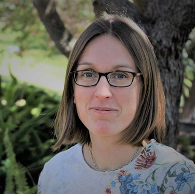
The History of the Mandan, Hidatsa, and Arikara Nation’s Food Sovereignty

Dr. Ruth De La Cruz
Friday, March 20, 2026
3:30-4:30 p.m.
Storm Hall 316
(Reception immediately following event)
Ruth De La Cruz, whose Hidatsa name is “Grows Different”, is an enrolled tribal member of the Three Affiliated Tribes and is Maxoxadi (Alkali Lodge) Clan. She is also descended from the Fort Peck Sioux and Assiniboine. She has gardened and gathered traditional foods and medicines with her family most of her life. She earned degrees in environmental science, education, biology, and forestry. Currently, she serves as the Food Sovereignty Director at Nueta Hidatsa Sahnish College where she works on developing the college’s traditional seed cache through seed rematriation and multiplication. She co-owns a traditional foods business, Bear Roots, with her husband. They cater and facilitate traditional foods workshops and cooking classes.
Co-sponsored with The Center for Better Food Futures
Course-based Undergraduate Research Experiences in Field Geography Classes

Dr. Jasmine Arpagian
Friday, March 6, 2026
3:30-4:30 p.m.
Storm Hall 316
(Reception Immediately following event)
Jasmine Arpagian is an assistant professor of geography at California State University, Sacramento. She holds degrees from University of California, Los Angeles; University of Michigan; and San Diego State University (Ph.D. in Geography). She teaches upper-division courses on human geography, urban planning, European geography, and geographic information systems. At Sacramento State, she also leads several community-engaged and course-based research projects. Jasmine’s research ranges from informal housing in Romania to the intersection of race and housing in the Sacramento region, and Youth-friendly urban planning.
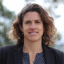
Distinguished Getis Lecture in Spatial Analysis: Spatial Thinking for Curiosity and Innovation in Artificial Intelligence

Dr. May Yuan
Friday, February 27, 2026
3:30-4:30 p.m.
Art & Letter 101
(Reception immediately following)
In the past 5 years, we have seen a surge in Artificial Intelligence (AI) applications in geospatial research. From classic machine learning (ML) methods to agentic AI, geospatial researchers not only apply established ML algorithms and AI frameworks but also develop spatially explicit ML/AI models for spatial data curation, spatial mapping, and spatial prediction. Many publications introduced spatial variables, geographic weights, and place embeddings to “spatialize” ML and AI for improved model performance or task automation. Beyond this prevailing trend, what may we have overlooked in ML/AI for geospatial research? In this talk, I share how I think spatial thinking (including geographic thinking) as the primary driver of new trends in geospatial research in the past, its contribution to ML/AI algorithmic advances, and its potential as an agent of curiosity and innovation for scientific inquiry in geospatial research.
May Yuan is the Ashbel Smith Professor of Geospatial Information Sciences in the School of Economic, Political, and Policy Sciences at the University of Texas at Dallas, with all her degrees in Geography: B.S. 1987 from National Taiwan University, and M.S. 1992, and Ph.D. 1994 from the State University of New York at Buffalo. She is an elected fellow of the American Association for the Advancement of Science (AAAS), the American Association of Geographers (AAG), and the University Consortium of Geographic Information Science (UCGIS). She currently serves as the Editor-in-Chief of the International Journal of Geographical Information Science. Previously, she served as a program director for Human-Environment and Geographic Science at the U.S. National Science Foundation (2022-2025). Her research has been supported by NSF, NASA, DoD, DHS, DOJ, DOE, NOAA, USGS, NIST, and NIH. She and her students at the Geospatial Analytics and Innovative Applications (GAIA) Lab explore ways to understand the dynamics of people, events, and places, and how interactions between spatial behaviors and the environment affect brain health and cognitive development.
Social, Local, and Landscape Drivers of Arthropod Diversity, Traits, and Networks in Urban Agroecosystems
Dr. Stacy Philpott
Friday, February 20, 2026
3:30-4:30 p.m.
Storm Hall 316
(Reception immediately following event)
Stacy Philpott is a Professor of Environmental Studies and the Alfred and Ruth Heller Chair in Agroecology at the University of California, Santa Cruz. She also serves as Faculty Director of the UCSC Center for Agroecology and Dean of the UCSC Agricultural Experiment Station. She holds a PhD in Ecology and Evolutionary Biology from the University of Michigan and a BS in Zoology from the University of Washington.
Dr. Philpott is an agroecologist whose research focuses on community ecology, ecosystem services, urban agroecology, and the interactions between agriculture, conservation, and farmer well-being. Her work examines how farm management practices, surrounding landscapes, and social context influence plant, arthropod, and bird diversity, ecological networks, and ecosystem services in farms and gardens. She has conducted extensive research in tropical agroforestry systems in Mexico and urban agroecosystems in California.
Dr. Philpott has authored more than 160 research articles and book chapters, is a Fellow of the Ecological Society of America, and has served as Project Director on more than $14 million in USDA-funded projects supporting agriculture and food systems education and workforce development.
"A Case for Replication in Geography"

Dr. Peter Kedron
Friday, November 21, 2025
3:30-4:30pm
Storm Hall 109
(Reception Immediately Following)
Peter Kedron is an Associate Professor in the Department of Geography at the University of California Santa Barbara, and an Associate Director of the Center for Spatial Studies and Data Science. He develops analytical methods, research approaches, and pedagogical models to build a reproducible and reliable spatial science. Dr. Kedron’s recent work focuses on bringing a geographic approach to understanding not only what policies work, but what policies work where.
"From Coordinates to Conservation: Leveraging Ecological Niche Models for Ecological Integrity"
Dr. Reza Goljani Amirkhiz
Friday, November 7, 2025
3:30-4:30pm
Storm Hall 316
(Reception Immediately Following)
Biodiversity loss driven by climate and land-use change is a pressing global concern. Addressing this challenge requires rapid, large-scale approaches to monitor species and habitats across both time and space. In recent decades, remote sensing has revolutionized our ability to monitor biodiversity from space, providing multi-decadal spatial datasets that capture habitat changes over time.
Spatial ecology, an emerging field, seeks to understand how spatial patterns relate to ecological processes. Fundamental questions in this field include: Why do species occur in certain areas and not others? And how are human activities and climate change reshaping species’ geographic distributions and biodiversity? Ecological Niche Models (ENMs) have become essential tools for exploring these questions. While producing species distribution maps has become increasingly accessible with advances in machine learning and AI, ENMs offer much more than mapping capabilities. They provide a framework for testing ecological theories across scales and generating hypotheses about the mechanisms driving species patterns.
In this talk, I will explore how ENMs can be leveraged both to advance ecological theory and to address real-world conservation challenges. I will show how these models can inform the design of wildlife corridors and management strategies for game species. I will also highlight how incorporating hierarchical habitat selection theory into ENMs can improve our understanding of rare and data-deficient species, supporting more effective conservation decisions. Finally, I will share examples of how historical species records can be used to assess the impacts of land use and climate change on biodiversity over time.
"Locating Harm Reduction Services: An Integrated Spatial Modeling Approach"
Professor Elijah Knaap
Friday, October 17, 2025
3:30-4:30 p.m.
Storm Hall 316
(Reception Immediately Following)
Elijah Knaap is an Assistant Professor of Urban Planning and Public Policy at UC Irvine, a faculty affiliate with the UCI Center for Population Inequality and Policy, and a core software developer for the PySAL and QuantEcon open-source ecosystems. His work focuses on the development and application of novel techniques in spatial data science, particularly toward the study of social inequality, neighborhood context, and urban structure. Eli's research has received support from the National Science Foundation, the National Institutes of Health, the U.S. Dept of Housing and Urban Development, the Bill and Melinda Gates Foundation, the Urban Institute, the Lincoln Institute for Land Policy, and the National Cooperative Highway Research Program, among others. He serves on the North American Regional Science Council and as Secretary of the Northeastern Regional Science Association.
"Mapping Hydrologic Processes at Continental to Global Scales"
Dr. Hilary McMillan
Friday, October 3, 2025
3:30-4:30 p.m.
Storm Hall 316
(Reception Immediately Following)
Hilary McMillan is Professor of Water Resources in the Geography Department at San Diego State University. Hilary and her students study hydrology and water resources in a range of landscapes from pristine mountain headwaters to highly modified urban catchments. She focuses on the value of many types of hydrologic data to improve understanding of hydrologic processes and build accurate quantitative models to predict river flow, soil moisture, groundwater recharge and other quantities.
Dissertation Presentations
Contested Arctic: Cultural Heritage, Abjection, and Environmental Change in Northernmost
Alaska
Daniel Grafton
Wednesday, April 22, 2026
1-2 p.m.
Storm Hall 337 and Zoom
Committee Members: Dr. Amy Quandt, Chair, Dr. Vena Chu, Dr. Stuart Aitken, Dr. Susan
Cassels
Geography Awareness Week
 November 17-21, 2025
Mon, Nov 17
- Opening Day - Games & Prizes
- 11a-2p, Campanile Walkway near flagpole
Tue, Nov 18
- ASPRS Lunch @ 12pm, SH 312
- ASPRS Guest Speaker @ 2pm, AL 101 Main Event
Wed, Nov 19
- GGSA Coffee Hour and Graduate Info Session @ 10am, SH 312
- GIScience Day - Drone Demo @2-5pm, ENS 700 - Field by Music Bldg
Thu, Nov 20
- Alumni Panel hosted by GGSA - Zoom
- Trivia/Game Night with Undergrad Club - 3:30pm, Council Chambers
Fri, Nov 21
- Colloquium Series with Dr. Peter Kedron -
3:30pm, SH 109
And More
Photo Contest,
Reception following Speakers,
Geography Swag,
Geography Club Mixer
For more information, visit SH 314 or email [email protected].
Past Events
Colloquia Series
Talk Title: TBD
Jorge Santiago Urbina
Friday, May 2, 2025
3:30-4:30 p.m.
Storm Hall 316
Reception Immediately Following
Implications of Cartographic Thinking for Inventive Education
Dra. Carolina Rodrigues de Souza
Friday, April 18, 2025
3:30-4:30 p.m.
Storm Hall 316
Reception Immediately Following
Education, historically influenced by normative and standardised models, has been thought on the basis of fixed structures that delimit ways of learning and teaching. The cartographic method, inspired by Gilles Deleuze and Félix Guattari, proposes a procedural and non-linear approach in which learning emerges as an event traversed by singular and unpredictable experiences. The aim of this colloquium is to discuss the potential of cartography as a conceptual and practical tool for rethinking education, especially in the teaching of science and its intersections with the arts. Through dialogue between different perspectives, we will seek to problematize traditional teaching models and explore ways of inventive learning that values learning as an aesthetic, ethical and sensitive experience.
Carolina Rodrigues de Souza is a professor at the Federal University of São Carlos (Brasil), working in the Department of Teaching Methodology. Her contributions to the field of education engage with the philosophy of difference, specifically exploring the relationship between science and art to reflect on teacher education and learning processes.
Measuring Changing Forest Disturbance Regimes
Dr. Emily Francis
Friday, April 11, 2025
3:30-4:30 p.m.
Storm Hall 316
Reception Immediately Following
Emily Francis is an Assistant Professor at Colorado State University in the Department of Forest
and Rangeland Stewardship. Her research is focused on understanding how forest disturbances
are changing with climate change and past management, and on developing new measurement
tools to support forest management and to study dynamics of forest composition and
structure. Emily finished her Ph.D. in Environmental Earth System Science from Stanford
University in 2019. When she is not doing science, Emily enjoys rock climbing.
Use of species distribution models in biodiversity conservation
Dr. Santiago José Elías Velazco
Friday, March 14, 2025
3:30-4:30 p.m.
Storm Hall 316
Reception Immediately Following
Species distribution models (SDM) are statistical tools that model species-environment relationships by combining species occurrences with spatialized environmental variables to predict species' suitable habitat and distributions. Using my research from across the Neotropics, I will present how the SDM can help address conservation issues. We will explore: 1-how the SDM can assist in detecting priority areas for new botanical collections in the Gran Chaco region and southern Brazilian grassland. 2-how species distributions can be combined with the diversity of uses of legumes native to Argentina. 3-how climate change and land use may affect the phylogenetic diversity of palms in the Neotropics, and 4-investigate the relationship among Cerrado flora, natural cover loss, priority areas for conservation, and their interaction with country boundaries in Bolivia, Brazil, and Paraguay.
Santiago Velazco, native of Argentina, has B.S. (2010), M.S. (2014), and Ph.D. (2018) in Forest Engineering.
Currently, he is a Research Scientist at the Department of Geography (SDSU), a Researcher
at the Institute of Subtropical Biology (UNaM-CONICET, Argentina), and an Affiliated
Professor at the Graduate Program in Neotropical Biodiversity (UNILA, Brazil). His
research is related to biological conservation, conservation biogeography, and spatial
ecology. His research seeks to understand the effect of global change on biodiversity
(mainly in the Neotropics), detect priority areas for conservation, improve methods
used in species distribution models, and develop R packages linked to spatial ecology
and biological data cleaning.
The Amazon Tall Tower Observatory (ATTO) - Linking the Amazon Rainforest to the Atmosphere
Dr. Cléo Quaresma and Dr. David Adams
Friday, February 7, 2025
3:30-4:30 p.m.
Storm Hall 316
The Amazon rainforest plays a critical role in Earth’s climate system and, therefore, deforestation has implications for global warming, ecosystem health, and extreme hydrometeorological events. How to directly link forest ecosystem behavior with the overlying atmosphere was the motivation for the construction of the 325-m Amazon Tall Tower Observatory (ATTO) in 2015. The ATTO site is located around 150km northeast of Manaus in the central Amazon. ATTO provides a wide-range of meteorological, chemical and biological data. In this presentation, we will describe the unique data from the ATTO tower site with brief overviews of how these data provide links between the rainforest and atmosphere, for example, the temporal evolution of the boundary layer. We then discuss our joint project with SDSU Geography, IFPA (Brazil) and UNAM (Mexico) sponsored by SDSU’s Behner Stiefel Center for Brazilian Studies. Specifically, our experiment focuses on quantifying forest evaporation and rainfall events, both locally, as well as downstream, a fundamental science question, not only, in the atmospheric sciences, but also for forest ecological functioning and the potential effects of deforestation. Two GPS meteorological receivers placed at the top of both the ATTO and nearby flux tower will continually measure total column water vapor. Likewise, rainforest water vapor fluxes are measure continuously at several tower levels providing an estimate of forest water vapor contribution for days with and without precipitation. Having an estimate of forest ecosystem water vapor fluxes to storm activity is critical for evaluating regional and global climate models’ ability to properly replicate this important process known as moisture recycling.
 Dr. Cléo Quaresma is a Professor in the Physics Department at the Instituto Federal do Pará (IFPA)
in Brazil. He obtained his undergraduate and Master’s degrees in Environmental Sciences
at the Federal University of Pará and PhD in Climate and Environment at the National
Institute for Research in the Amazon, Brazil. He has experience in Micrometeorology,
with emphasis on turbulent exchanges at the forest-atmosphere interface; energy and
mass transport downdrafts events, planetary boundary layer height, and forest-atmosphere
interactions. Since 2021, he has been the micrometeorology coordinator of the Amazon
Tall Tower Observatory (ATTO) project.
Dr. Cléo Quaresma is a Professor in the Physics Department at the Instituto Federal do Pará (IFPA)
in Brazil. He obtained his undergraduate and Master’s degrees in Environmental Sciences
at the Federal University of Pará and PhD in Climate and Environment at the National
Institute for Research in the Amazon, Brazil. He has experience in Micrometeorology,
with emphasis on turbulent exchanges at the forest-atmosphere interface; energy and
mass transport downdrafts events, planetary boundary layer height, and forest-atmosphere
interactions. Since 2021, he has been the micrometeorology coordinator of the Amazon
Tall Tower Observatory (ATTO) project.
 Dr. David K. Adams is a Professor and Researcher in the Instituto de Ciencias de la Atmósfera y Cambio
Climático at the Universidad Nacional Autónoma de México. He received his doctorate
in Atmospheric Sciences from the University of Arizona and a postdoc at the Scripps
Institute of Oceanography, the University of California, San Diego. Between 2007 and
2012, he was a professor in the Climate and Environment Program at the Universidade
do Estado do Amazonas/Instituto Nacional de Pesquisa da Amazônia in Brazil. His area
of study is atmospheric convection, thermodynamics and satellite meteorology, specifically
GPS meteorology. His work has principally focused on convection in the Tropics and
monsoon regime in North America employing a wide variety of remote sensing techniques
as well as numerical modeling.
Dr. David K. Adams is a Professor and Researcher in the Instituto de Ciencias de la Atmósfera y Cambio
Climático at the Universidad Nacional Autónoma de México. He received his doctorate
in Atmospheric Sciences from the University of Arizona and a postdoc at the Scripps
Institute of Oceanography, the University of California, San Diego. Between 2007 and
2012, he was a professor in the Climate and Environment Program at the Universidade
do Estado do Amazonas/Instituto Nacional de Pesquisa da Amazônia in Brazil. His area
of study is atmospheric convection, thermodynamics and satellite meteorology, specifically
GPS meteorology. His work has principally focused on convection in the Tropics and
monsoon regime in North America employing a wide variety of remote sensing techniques
as well as numerical modeling.
Distinguished Getis Lecture in Spatial Analysis: Spatial is Special
 Dr. Rachel Franklin
Newcastle University
Friday, November 22, 2024
3:30-4:30pm
Ochoa Pavilion 230
Rachel Franklin is Group Leader for Liveability in the Urban Analytics Programme at
Turing and Professor of Geographical Analysis in the Centre for Urban and Regional
Development Studies (CURDS) at Newcastle University. At Newcastle, she is also Head
of Newcastle Data, the University’s centre for research excellence in data. In addition,
she is part of the team leading the interdisciplinary EPSRC Centre for Doctoral Training
in Geospatial Systems. Prior to joining Newcastle and Turing, she was the Associate
Director of Brown University's initiative in Spatial Structures in the Social Sciences
(S4), in the U.S. She is trained as a quantitative human geographer and her research
focus is in spatial demography and the interplay between spatial analytics and demographic
change, in particular quantifying patterns, sources and impacts of spatial inequality.
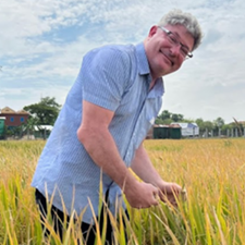
A tool to address restoration efforts and the role of trees outside of forests in rural livelihoods: Mapping African semi-arid trees at the tree level south of the Sahara & north of the Equator
Dr. Compton Tucker
Senior Scientist, Earth Sciences and Exploration Directorate
NASA/Goddard Space Flight Center
Greenbelt MD
Friday, November 8, 2024
3:30-4:30pm
Storm Hall 316
We used 50 cm spatial resolution commercial satellite data to address the role of trees outside of forests in agriculture, in restoration efforts, and in rural livelihoods in Africa south of the Sahara and north of the equator. By using 50 cm satellite data and high-performance computing, we mapped 10 billion trees in semi-arid Africa and converted them into carbon at the tree level from the Atlantic Ocean to the Red Sea. Maxar 50 cm data, high-performance computing, and machine learning make this possible. Accurate monitoring of tree resources at the level of individual trees is instrumental for tree-planting initiatives, for reporting the correct number of trees and carbon stocks for national reporting schemes, and to have a reliable system for payments for environmental services to farmers and villages. Although deforestation and afforestation areas
Compton Tucker, a native of New Mexico, received his B.S. degree in 1969, a M.S in
1973, and a Ph.D. in 1975, all from Colorado State University. He came to NASA/Goddard
in 1975 as a National Academy of Sciences post-doctoral fellow and became an employee
of NASA in 1977. At NASA/Goddard, Tucker has used satellite data to study the Pale
Blue Dot in research areas including famine early warning, deforestation, weather-coupled
diseases, terrestrial primary production, glacier extent, and semi-arid tree carbon.
He was active in NASA’s Space Archaeology Program mapping ancient sites at Troy, the
Granicus River Valley, and at Gordion, all in Turkey over 10 years using radar & magnetometry.
He is an adjunct professor at the University of Maryland, a consulting scholar at
the University of Pennsylvania’s Museum of Archaeology and Anthropology, a fellow
of the AGU, and a fellow of the AAAS.
The Geography of Arsenic Scaling Geochemistry to Landscapes
Dr. Ben Bostick
Lamont Research Professor, Lamont-Doherty Earth Observatory of Columbia University
and the Columbia Climate School
Friday, October 18, 2024
3:30-4:30pm
Storm Hall 316
Ben Bostick is a Lamont Research Professor at the Lamont-Doherty Earth Observatory
of Columbia University and the Columbia Climate School. Ben is an expert in aqueous
geochemistry, with decades of experience leading field and laboratory research, including
applications in human health and agriculture in Southeast Asia. Ben is also the director
of the Next Generation of Hudson River Educators, a six-week summer program specifically
designed to more effectively connect historically underrepresented high school students
and under-resourced communities to the Hudson River in upstate New York.
Climate Change, Public Health, and Community Resilience: Addressing Vulnerabilities Across Contexts
Dr. Maya Negev
Head, Health Systems Policy and Administration Program
School of Public Health
The Health and Climate Resilience Lab
Friday, September 27, 2024
3:30-4:30pm
Storm Hall 316
Climate change is one of the biggest challenges for humanity in the 21st century, with severe consequences for public health. The Mediterranean is a climate hotspot, where temperatures rise above the global average and extreme climate events including heatwaves, droughts, floods have intensified. This presentation will explore vulnerabilities associated with climate change, their distribution among diverse populations, and resulting health impacts. This presentation will feature mixed-methods case studies from urban and arid environments in Israel, encompassing diverse geographic, ethnic, and social contexts. Vulnerable populations (e.g., the elderly, low-income, ethnic minorities) are disproportionately exposed to climate hazards and have fewer means to adapt. The impact of climate change on the health of vulnerable populations is exacerbated by gaps in infrastructure, health services and individual adaptation. For example, in a national study (N=30,997) we found that heat and humidity are significantly associated with stroke, with stronger associations observed in individuals of low and middle socioeconomic status. In another national study (N=1,492), 46% reported missing a medical appointment due to extreme climate, including 65% of Muslims and 35% of Jews. Another study of the Arab-Palestinian population in Israel (N=566) found that 43.3% reported experiencing negative consequences from at least one climate hazard. The talk will highlight the importance of enhancing climate resilience tailored to local needs and engaging with policy-makers and communities.
Prof. Negev’s work is at the science-policy interface of public health and climate change. She heads the Health and Climate Resilience Lab, studying climate and health across governance levels and across sectors, through mixed methods and interdisciplinary research. She serves as the head of the Health Systems Policy and Administration Program at the School of Public Health, University of Haifa, a policy committee member at the International Society for Environmental Epidemiology, chair of the Israeli Taub Center’s Environment and Health Initiative, and a member of the Board of Directors of the Arava Institute for Environmental Studies, the premier academic institute for cross-border environmental studies in the Middle East.
General Events
Geography Awareness Week
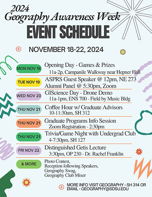 November 18-22, 2024
Mon, Nov 18
- Opening Day - Games & Prizes
11a-2p, Campanile Walkway near Hepner Hall
Tue, Nov 19
- ASPRS Guest Speaker @ 12pm, NE 273
- Alumni Panel @ 5:30pm, Zoom
Wed, Nov 20
- GIScience Day - Drone Demo
11a-1pm, ENS 700 - Field by Music Bldg
Thu, Nov 21
- Coffee Hour w/ Graduate Advisors
10-11:30am, SH 312 - Graduate Programs Info Session
Zoom Registration - 2:30pm - Trivia/Game Night with Undergrad Club
4-7:30pm, SH 127
Fri, Nov 22
- Distinguished Getis Lecture
3:30pm, OP 230 - Dr. Rachel Franklin
And More
Photo Contest,
Reception following Speakers,
Geography Swag,
Geography Club Mixer
For more information, visit SH 314 or email [email protected].
Colloquia Series
American Society for Photogrammetry & Remote Sensing (ASPRS) SDSU Student Chapter
Hosts
Spring Technical Meeting with Keynote/Geography Colloquium
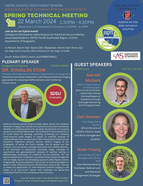 Friday March 22, 2024
Storm Hall 119
3:30 PM Colloquium/Keynote Presentation:
Dr. Douglas Stow
Emeritus Distinguished Professor, Department of Geography
Dr. Stow will discuss: Crewed and uncrewed: Systematic Multi-Temporal Airborne Imaging Approaches
for Analyzing Wildfire Behavior and Monitoring Infrastructure.
1:30 to 3:20 PM ASPRS Professional Presentations:
Garrett McGurk
CW3E, Scripps Institute of Oceanography
Garrett McGurk will discuss: Spills of a Storm chaser: Advancing Forecast Informed Reservoir Operations
through Hydrologic Monitoring and Photogrammetry.
Zuzi Gounev
San Diego Gas and Electric
Zuzi Gounev will discuss: GIS at the core of SDGE's Electric Asset and Work Management Systems.
Noah Young
U.S. Bureau of Land Management (BLM), NV5
Noah Young will discuss: How Remote Sensing Facilitates Federal Land and Resource Management
Strategies.
Reception immediately following presentation (4:30 PM)
Storm Hall 312
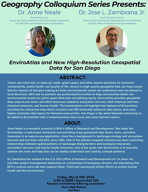
EnviroAtlas and New High-Resolution Geospatial Data for San Diego
 Friday March 15, 2024
3:30-4:30 pm
Storm Hall 320
Anne Neale
EnviroAtlas Lead
Center for Public Health and Environmental Assessment
US EPA Office of Research and Development
José L. Zambrana, Jr.
Senior Science Advisor
Center for Environmental Measurement and Modeling
US EPA Office of Research and Development
Abstract: Towns and cities rely on clean air, water, green space, and other natural amenities for economic sustainability, public health, and quality of life. Access to high quality geospatial data can help ensure that the impacts of decision-making on these environmental assets are understood and considered in local decisions. EPA and its partners are producing EnviroAtlas to help communities better use environmental assets for public good while also considering equity. EnviroAtlas provides geospatial data, easy-to-use tools, and other resources related to ecosystem services, their chemical and non-chemical stressors, and human health. This presentation will highlight key features of EnviroAtlas, including the interactive map which includes over 500 nationally-extensive data layers, and many higher resolution data layers for featured communities. San Diego is the latest featured community to be added to EnviroAtlas with 1-meterresolution land cover and many derived metrics.
About Anne: Anne Neale is a research scientist in EPA’s Office of Research and Development. She leads the EnviroAtlas, a web-based interactive tool providing many geospatial data layers, tools, and other resources in an easy-to-use application. Anne has a background in landscape ecology and ecosystem services and has been with EPA since 1991. One of her primary research interests has been examining relationships between spatial patterns of landscape characteristics and ecological resources, ecosystem services, and human health outcomes. One of her goals with EnviroAtlas is to translate science into tools and data that can be readily understood and used by a broad audience.
About Jose: Dr. Zambrana has worked at the U.S. EPA Office of Research and Development for 14 years. He provides project management leadership on contaminants of emerging concern, and translating how EPA’s science tools can best support State, Tribal and community-driven efforts to protect human health and the environment.
How hot is too hot for farm workers in the Imperial Valley?
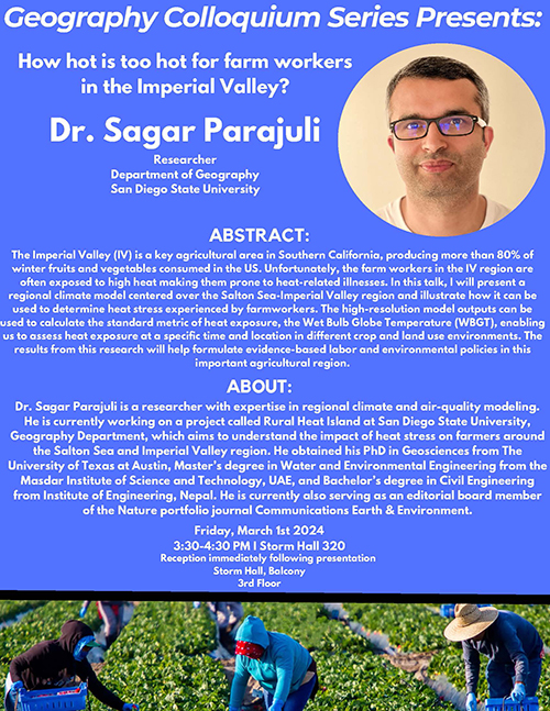 Friday, March 1, 2024
3:30-4:30 pm
Storm Hall 320
Dr. Sagar Parajuli
Researcher, Department of Geography
San Diego State University
Abstract: The Imperial Valley (IV) is a key agricultural area in Southern California, producing more than 80% of winter fruits and vegetables consumed in the US. Unfortunately, the farm workers in the IV region are often exposed to high heat making them prone to heat-related illnesses. In this talk, I will present a regional climate model centered over the Salton Sea-Imperial Valley region and illustrate how it can be used to determine heat stress experienced by farmworkers. The high-resolution model outputs can be used to calculate the standard metric of heat exposure, the Wet Bulb Globe Temperature (WBGT), enabling us to assess heat exposure at a specific time and location in different crop and land use environments. The results from this research will help formulate evidence-based labor and environmental policies in this important agricultural region.
About: Dr. Sagar Parajuli is a researcher with expertise in regional climate and air-quality modeling. He is currently working on a project called Rural Heat Island at San Diego State University, Geography Department, which aims to understand the impact of heat stress on farmers around the Salton Sea and Imperial Valley region. He obtained his PhD in Geosciences from The University of Texas at Austin, Master’s degree in Water and Environmental Engineering from the Masdar Institute of Science and Technology, UAE, and Bachelor’s degree in Civil Engineering from Institute of Engineering, Nepal. He is currently also serving as an editorial board member of the Nature portfolio journal Communications Earth & Environment.
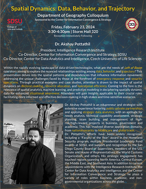
Spatial Dynamics: Data, Behavior, and Trajectory
 Friday, February 23, 2024
3:30-4:45 pm
Storm Hall 320
Dr. Akshay Pottathil
President, Intelligence Research Institute
Co-Director, Center for Information Convergence and Strategy, SDSU
Co-Director, Center for Data Analytics and Intelligence, Czech University of Life
Sciences
Abstract: Within the rapidly evolving landscape of data-driven technologies, what are the needs of Left of Boom operators aiming to explore the nuanced relationships existing among data, behavior, and trajectory? This presentation delves into the spatial patterns and dependencies that influence information movement, addressing the unique challenges faced by those at the forefront of emergency response and security operations. Through practical examples and case studies, attention is drawn to the impact of spatial dynamics on decision-making, resource allocation, and operational efficiency. Coming to the fore is the relevance of spatial analytics, machine learning, and predictive modeling in deciphering spatially dynamic data for enhanced situational awareness. Attendees will gain insights applicable to their crucial roles facilitating more informed and effective decision-making in high-stakes and time-sensitive scenarios.
About: Dr. Akshay Pottathil is an edupreneur and strategist with extensive experience fostering public-private partnerships and applying strategic data analytics, with an aptitude for needs analysis, technical capability assessment, strategic planning, team building, and management of high-risk/high-reward projects in business, government and academia. This has involved diverse application domains, from national security to healthcare and global trade.
Dr. Pottathil’s efforts have been widely recognized, including a "Faculty of the Year" award in the Homeland Security program, multiple Presidential Leadership Fund awards at SDSU, and support and recognition by the San Diego County Board of Supervisors, members of the U.S. Senate and House of Representatives, the World Customs Organization, and others. His strategic engagement has touched regions spanning North America, Central Europe, the Middle East, and Southeast Asia. In addition to current appointments with the Intelligence Research Institute, the Center for Data Analytics and Intelligence, and the Center for Information Convergence and Strategy, he plays a variety of roles within business, academic, and non-governmental organizations across the globe.
Geography Colloquium Series
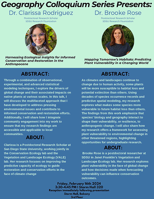 Friday, February 16, 2024
3:30-4:45 pm
Storm Hall 320
Reception immediately following presentation on the Storm Hall, Balcony (3rd Floor)
Harnessing Ecological Insights for Informed Conservation and Restoration in the Anthropocene
Clarissa Rodriguez, Ph.D.
Postdoctoral Research Scholar, SDSU Research Foundation
Through a combination of observational, experimental, and advanced statistical modeling techniques, I explore the drivers of global change and their associated impacts on native plants at various scales. In this talk, I will discuss the multifaceted approach that I have developed to address pressing environmental issues and contribute to informed conservation and restoration efforts. Additionally, I will share how I integrate community engagement into my work to ensure that my research findings are accessible and applicable to local communities.
Clarissa is a Postdoctoral Research Scholar at San Diego State University, working jointly in the Conservation Ecology lab and the Vegetation and Landscape Ecology (VALE)lab. Her research focuses on improving the predictive capacity of ecology to guide restoration and conservation efforts in the face of climate change.
Mapping Tomorrow’s Habitats: Predicting Plant Vulnerability in a Changing World
Brooke Rose, Ph.D.
Postdoctoral Research Scholar, SDSU Research Foundation
As climates and landscapes continue to change due to human activity, some plants will be more susceptible to habitat loss and potential extinction than others. Using decades of species occurrence records and predictive spatial modeling, my research explores what makes some species more vulnerable to future habitat loss than others. The findings from this work emphasize that species’ biology and geography interact to shape their vulnerability, or resilience, to anthropogenic change. I will also share how my research offers a framework for assessing plant vulnerability to environmental change in other threatened regions, highlighting opportunities for undergraduate research.
Brooke Rose is a postdoctoral researcher at SDSU in Janet Franklin’s Vegetation and Landscape Ecology lab. Her research explores plant vulnerability in the face of global change and how decisions made when forecasting vulnerability can influence conservation outcomes.
Google Earth Engine as a Tool for Climate Studies in the Brazilian Amazon
 Rodrigo Moreira
Associate Professor, Federal University of Rondônia, Brazil
Lecturer, Department of Geography, SDSU
Fall Fellow, Sustainability Fellowship, CBS/SDSU
Friday December, 2023
3:30-4:30pm
Storm Hall 316
Climate change poses a significant threat to the delicate ecosystems of the Brazilian Amazon, impacting its biodiversity, hydrology, and the livelihoods of millions of people. Understanding and monitoring climate patterns, particularly precipitation and temperature, is crucial for effective climate change mitigation and adaptation strategies in this region. We will explore the potential of Google Earth Engine (GEE) as a powerful tool for collecting and analysing data for climate science, with a focus on the Brazilian Amazon. GEE, a cloud-based geospatial platform developed by Google, offers access to a vast archive of satellite imagery and environmental datasets, enabling researchers to perform large-scale analyses with unprecedented efficiency and accuracy. It can serve as a pivotal tool for climate research in the Brazilian Amazon. Harnessing the power of GEE's geospatial analysis capabilities, researchers can contribute to a deeper understanding of climate change in this critical region, ultimately aiding in the development of informed policies and conservation strategies.
Dr. Moreira is a spatial data scientist who transforms multisensor (optical and radar) remote sensing products and census data into spatial information to answer complex environmental problems related to climate science, forest fragmentation, water resources and public health. Adjunct Professor at the Department of Environmental Engineering at the Federal University of Rondônia, promoting quality public education and popularization of science. Coordinator of the Laboratory of Geomatics and Statistics (LABGET - UNIR) and leader of the Environmental Engineering Research Group (GPEA - UNIR). Permanent Professor at the Environmental Sciences Graduate Program - UNIR. Postdoctoral research in progress at San Diego State University - USA, with a fellowship from the Behner-Stiefel Center of Brazilian Studies. Post-Doctorate in Natural Resources - UFMS (2020). PhD in Environmental Engineering Sciences - EESC/USP (2017) with a sandwich period at the University of Michigan - USA between 2016 and 2017. Master in Agricultural Sciences (2014), Environmental Sanitarian (2011) and Environmental Manager (2013) by IFGoiano - Campus Rio Verde.
Better Food Futures Colloquium Series Presents
Healing Grounds: Climate, Justice, and the Deep Roots of Regenerative Farming
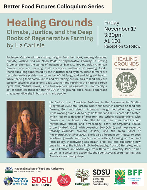 Liz Carlisle
Associate Professor
University of California, Santa Barbara
Friday, November 17, 2023
3:30-4:30pm
Arts & Letters 101
Professor Carlisle will be sharing insights from her book, Healing Grounds: Climate, Justice, and the Deep Roots of Regenerative Farming. In Healing Grounds, she tells the stories of Indigenous, Black, Latinx, and Asian American farmers who are reviving their ancestors’ methods of growing food— techniques long suppressed by the industrial food system. These farmers are restoring native prairies, nurturing beneficial fungi, and enriching soil health. While feeding their communities and revitalizing cultural ties to land, they are steadily stitching ecosystems back together and repairing the natural carbon cycle. This, Carlisle shows, is the true regenerative agriculture – not merely a set of technical tricks for storing CO2 in the ground, but a holistic approach that values diversity in both plants and people.
Liz Carlisle is an Associate Professor in the Environmental Studies Program at UC Santa Barbara, where she teaches courses on food and farming. Born and raised in Montana, she got hooked on agriculture while working as an aide to organic farmer and U.S. Senator Jon Tester, which led to a decade of research and writing collaborations with farmers in her home state. She has written three books about regenerative farming and agroecology: Lentil Underground (2015), Grain by Grain (2019, with co-author Bob Quinn), and most recently, Healing Grounds: Climate, Justice, and the Deep Roots of Regenerative Farming (2022). She is also a frequent contributor to both academic journals and popular media outlets, focusing on food and farm policy, incentivizing soil health practices, and supporting new entry farmers. She holds a Ph.D. in Geography, from UC Berkeley, and a B.A. in Folklore and Mythology, from Harvard University. Prior to her career as a writer and academic, she spent several years touring rural America as a country singer.
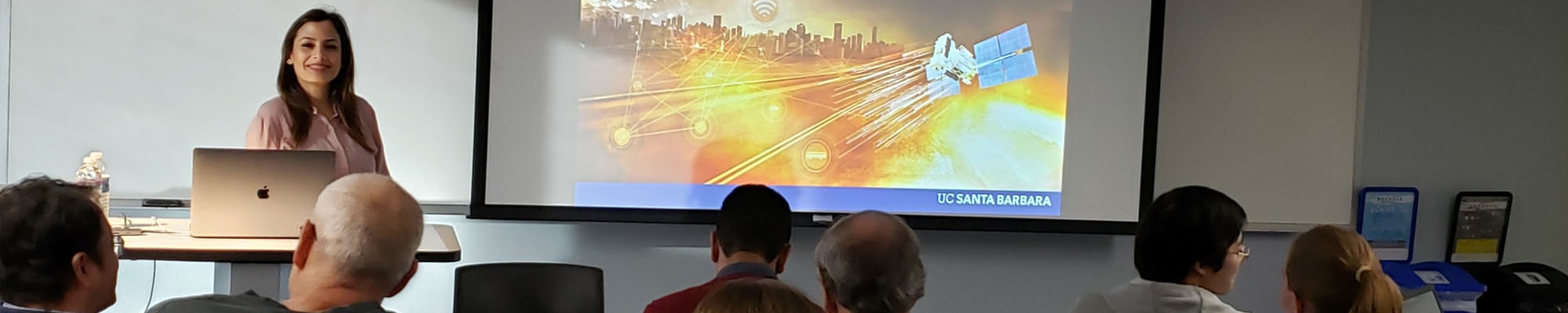
Getis Lecture in Spatial Analysis: Novel Spatial Data as a Path to Better Bicycling
Dr. Trisalyn Nelson
Dangermond Chair of Geography
University of California - Santa Barbara
Friday, November 3
3:30-4:30pm
Arts and Letters 101
Lack of available data can be a barrier to bicycling and pedestrian research and planning. Much of my team's research focuses on building novel data sources to map bicycling infrastructure, safety, and volume. In this presentation I will outline how we are using OpenStreetMaps to map bicycle infrastructure, crowdsource webmaps (BikeMaps.org and WalkRollMap.org) to map safety and access concerns, and modelling ridership using Strava data. I will discuss how crowdsource data provide unique opportunities to enhance active transportation data, but also challenges particularly around representativeness and equity.
Trisalyn Nelson joined the Department of Geography at UC Santa Barbara as Jack and Laura Dangermond Endowed Chair of Geography in 2020. In 2022 she became the Chair of the Department of Geography. From 2016-2020 she was Director of the School of Geographical Sciences and Urban Planning at Arizona State University. Prior, she was the Lansdowne Research Professor and Director of the Spatial Pattern Analysis and Research Lab at the University of Victoria, Canada.
Artificial Intelligence: Trust, Regulation and a Spatial Frontier
Dr. André Skupin
Department of Geography
San Diego State University
Friday, October 13
3:30-4:30pm
Storm Hall 316
Recent advances in generative AI have driven a blossoming interest in AI-based technologies of all kinds. For a few short months, anything seemed possible and plausible, with the space of imagination rapidly filled by concurrent threads of exuberance and doom. One might argue that the Wild West days of AI are already coming to an end. It was inevitable that the tremendous cost incurred in creating and maintaining foundational AI technologies, like large language models, in conjunction with growing adoption by end users, would require rapid monetization, as is indeed occurring. At the same time, while industry leaders may feign concern over civilization-threatening prospects of artificial general intelligence (AGI), trust in AI-based systems has been eroding even in their current incarnation. In response, such emerging legal frameworks as the EU AI Act agree that transparency – including through explainable AI (XAI) – is a key ingredient for engendering trust and regulatory compliance. This results in data visualization coming to the fore as a central element of responsible AI, while certain spatial concepts underlying geographic information science hold surprising clues for addressing shortcomings of current AI approaches.
André Skupin is a Professor of Geography and Co-Director of the Center for Information Convergence and Strategy (CICS) at San Diego State University. Dr. Skupin is a data visualization expert, with 30+ years of experience in the global analytics market, whose advice has been sought in domains as diverse as cardiology, law enforcement, bioinformatics, and wildlife management. As a thought leader in knowledge analytics, his R&D efforts have aimed at fusing AI-related approaches from machine learning with natural language processing and semantic computing. This has resulted in several patented technologies that are the basis of commercial knowledge management products. Sources of funding for Dr. Skupin’s research have included the National Science Foundation, National Institutes of Health, White House Office of National Drug Control Policy, Norway Research Council, and others. He is Chair of the SDSU Senate Committee on Freedom of Expression and was recently honored as the 2023 “Most Influential Faculty” in the interdisciplinary program in Urban Studies.
Dis/Continuities in the Epistemic and Cartographic Prison of Modernity/Coloniality
Dr. Roberto D. Hernández
Associate Professor
Chicana/o Studies
San Diego State University
Friday, September 29
3:30pm to 4:30pm
Storm Hall 316
 This talk aims to provide conceptual clarity on the “epistemic and cartographic prison
of Modernity/Coloniality,” a phrase first introduced in Coloniality of the U-S/Mexico Border (2018), where I argued nation-state borders are often taken for granted as normal,
necessary, and natural such that our own sense of self and ensuing epistemologies
are increasingly structured by them. Building an expanded theorization of Gloria Anzaldúa’s
notion of the border as an open wound, the talk advances an argument that national-territorial
borders - and border violence - are geographic manifestations of long histories of
racialized and gendered colonial violence. As such, the normalization of national-territorial
identities provides a mechanism for the naturalization of racial/ethnic and national
difference and contributes to a form of self-imprisonment. In turn, the reproduction
of the modern/colonial racial and gendered ordering of populations inhibits our human
capacity for imagination and for the thinking and building a world otherwise; one
free of borders or a world where many worlds co-exist.
This talk aims to provide conceptual clarity on the “epistemic and cartographic prison
of Modernity/Coloniality,” a phrase first introduced in Coloniality of the U-S/Mexico Border (2018), where I argued nation-state borders are often taken for granted as normal,
necessary, and natural such that our own sense of self and ensuing epistemologies
are increasingly structured by them. Building an expanded theorization of Gloria Anzaldúa’s
notion of the border as an open wound, the talk advances an argument that national-territorial
borders - and border violence - are geographic manifestations of long histories of
racialized and gendered colonial violence. As such, the normalization of national-territorial
identities provides a mechanism for the naturalization of racial/ethnic and national
difference and contributes to a form of self-imprisonment. In turn, the reproduction
of the modern/colonial racial and gendered ordering of populations inhibits our human
capacity for imagination and for the thinking and building a world otherwise; one
free of borders or a world where many worlds co-exist.
Dr. Hernández (Xicano) is an associate professor of Chicana and Chicano Studies at San Diego State University. His research, teaching and community commitments focus on the intersections of colonial and border violence, the politics of knowledge production, decolonial political theory, social movements and comparative border studies. He is the author of “Coloniality of the U.S./Mexico Border: Power, Violence, and the Decolonial Imperative” (Univ. of AZ Press, 2018), co-editor of “Decolonizing the Westernized University: Interventions in Philosophy of Education from Within and Without” (Lexington, 2016), and currently co-editing a special issue of the Journal of World-Systems Research (JWSR) on “Nationalisms and Sovereignty within the World-System” with Nandita Sharma of the University of Hawaii. He is the program director for two summer institutes, Decolonizing Knowledge and Power in Barcelona and Critical Muslim Studies in Granada, and a Spring Institute on Latin American Feminist and Decolonial Thought in Mexico City.
General Events
Join us for Geography Awareness Week: November 13-17
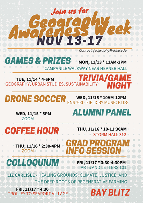
Games & Prizes
Mon, 11/13, 11 a.m.-2 p.m., Campanile Walkway near Hepner Hall
Trivia/Game Night (Geography, Urban Studies, Sustainability)
Tue, 11/14, 4-6 p.m.
Drone Soccer
Wed, 11/15, 10 a.m.-12 p.m., ENS 700 - Field by Music Bldg
Alumni Panel
Wed, 11/15, 5 p.m., Zoom
Coffee Hour
Thu, 11/16, 10-11:30 a.m., Storm Hall 312
Grad Program Info Session
Thu, 11/16, 2:30-4 p.m, Zoom
Colloquium - Healing Grounds: Climate, Justice, and the Deep Roots of Regenerative Farming with Liz Carlisle
Fri, 11/17, 3:30-4:30 p.m., Arts and Letters 101
Bay Blitz
Trolley to Seaport Village
Fri, 11/17, 4:30 p.m.
Contact: [email protected]
Learn More About Our Graduate Programs
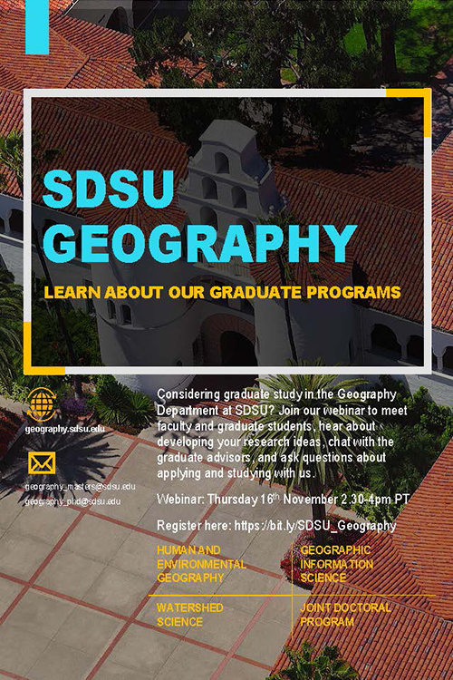 Considering graduate study in the Geography Department at SDSU?
Join our webinar to meet faculty and graduate students, hear about developing your research ideas, chat with the graduate advisors, and ask questions about applying and studying with us.
- Human and Environmental Geography
- Geographic Information Science
- Watershed Science
- Joint Doctoral Program
Thursday, November 16
2:30-4 p.m. PT
Need more info? Email our prgrams: [email protected] or [email protected]
Dissertation Presentations
Climate Dynamics and Agricultural Adaptability in the Brazilian Amazon
Tuesday, May 21, 2024
10-11 a.m.
on Zoom
Corrie Monteverde
Committee Members: Dr. Fernando De Sales, Chair, Dr. Amy Quandt, Dr. Trent Biggs, Dr. Charles Jones, Dr. Leila Carvalho
Current and Future Adaptation to a Changing Climate in the California Market Squid and California Spiny Lobster Fisheries
Friday May 17, 2024
1-2:30 p.m.
on Zoom
Farrah Powell
Committee Members: Dr Arielle Levine (Chair), Dr. Atsushi Nara, Dr. David Lopez-Carr (UCSB), Dr. Hunter Lenihan (UCSB)
Satellite-derived estimates of herbaceous fractional cover and its influence on fire regime in San Diego County, California, USA shrublands
Krista West
Friday December 8, 2023
2-4:30 p.m.
Zoom Session
Thesis Presentations
New Predictors for Hydrologic Signatures: Wetlands and Geological Age Across Continental Scales
Annie Holt
Thursday May 30, 2024
11 a.m. - 12 p.m.
Location: Storm Hall 325 and Zoom
Committee members:
Dr. Hilary McMillan
Dr. Trent Biggs
Dr. Matthew Weingarten
Quantifying Riverine Debris: Applying a Mass Balance Model in the San Diego River
TJ Palmer
Wednesday, May 22, 2024
2-3 p.m.
Location: Storm Hall 325 and Zoom
Committee members:
Dr. Hilary McMillan
Dr. Trent Biggs
Dr. Hassan Davani
Shrinking Coastlines: Use of Uncrewed Aerial Sensing Systems to Map and Monitor Rocky Intertidal Habitats
Elizabeth Bushnell
Friday, May 17, 2024
1-2:30 p.m.
Location: Storm Hall 325 and Zoom
Committee members:
Dr. Douglas Stow
Dr. Trent Biggs
Dr. Rafael Almeida
Machine Learning Detection of Antropogenic Debris in Complex Floodplain Environment
Peaceibisia Benebo Jack
Monday, May 13, 2024
9-10:30 a.m.
Location: Storm Hall 325 and Zoom
Committee Members:
Dr. Trent Biggs
Dr. Daniel Sousa
Dr. Xin Zhang
Documenting Traditional Marine Fishery Practices in the Republic of Palau Though Rebuilding Indigenous Fish Traps
Reid Endress
Wednesday, May 8, 2024
9:30-10:30 a.m.
Location: Storm Hall 331 and Zoom
Committee Members:
Dr. Arielle Levine
Dr. Amy Quandt
Dr. Matthew Lauer
Elders' perspectives on the environment: A collaborative exploration for brownfield revitalization in National City, CA
Jacqueleen Weeden
Monday, May 6, 2024
11 a.m.-12:30 p.m.
Location: Storm Hall 331 and Zoom
Committee Members:
Dr. Amy Quandt
Dr. Jessica Barlow
Dr. Madison Swayne
Identifying Producer Perspectives on Repurposed Land Strategies in Kern County, California
Gracie Bartel
Wednesday, April 10, 2024
10 a.m.
Location: Storm Hall 331
Committee Members:
Dr. Amy Quandt
Dr. Trent Biggs
Dr. Ramona Perez
(Dis)placing Airbnb: Neighborhood Perspectives on Short-term Rentals and Gentrification
Nicolas Vadun-Lemp
Thursday, November 28, 2023
2:30-5 p.m.
Location: Storm Hall 325 and via Zoom
Committee members:
Dr. Fernando Bosco (Chair)
Dr. Pascale Joassart-Marcelli
Dr. Bruce Appleyard
Colloquia Series
Unraveling the Interlinkages of the Water-Energy-Food Nexus Towards Achieving Security in the Three Sectors

Dr. Olusola Ololade
Associate Professor
Center for Environmental Management
University of the Free State, Bloemfontein, South Africa
Research Associate
Environmental and Ocean Sciences
University of San Diego
Visiting Faculty
Department of Geography
San Diego State University
Friday, September 23
3:30pm to 4:30pm
Storm Hall 316
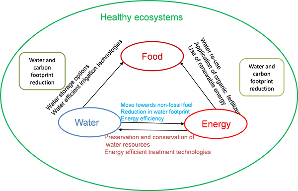 Uncertainties brought about by climate change have highlighted the interdependent
relationship between water, energy, and food security. These three sectors have also
been identified as areas of priorities for the achievement of sustainable development
goals (SDGs). Research has shown that violence, uncertainty and unrest go hand in
hand with food, water and energy scarcity globally. Establishing the link between
the WEF Nexus and the SDGs is very crucial. This can be done by identifying the drivers
behind this link as well as the corresponding responses. Outcomes of pilot projects
and research done within the South African context are indicative of the need to emphasis
the need to develop the WEF Nexus concept. This involves recognizing, understanding,
and evaluating the linkages between related disciplines and sectors that will lead
to efficient use of resources in the three sectors in a sustainable manner.
Uncertainties brought about by climate change have highlighted the interdependent
relationship between water, energy, and food security. These three sectors have also
been identified as areas of priorities for the achievement of sustainable development
goals (SDGs). Research has shown that violence, uncertainty and unrest go hand in
hand with food, water and energy scarcity globally. Establishing the link between
the WEF Nexus and the SDGs is very crucial. This can be done by identifying the drivers
behind this link as well as the corresponding responses. Outcomes of pilot projects
and research done within the South African context are indicative of the need to emphasis
the need to develop the WEF Nexus concept. This involves recognizing, understanding,
and evaluating the linkages between related disciplines and sectors that will lead
to efficient use of resources in the three sectors in a sustainable manner.
Dr. Olusola (Shola) Ololade was appointed as a lecturer at the Centre for Environmental Management, University of the Free State Bloemfontein Campus, in 2015 and is a South African National Research Foundation (NRF) rated scientist. She obtained her PhD in Environmental Management from the University of Johannesburg in 2012 with a thesis titled “Evaluation of the environmental impacts and sustainability of mining in the Rustenburg region”. She is currently an Associate Professor in Environmental Management at the University of the Free State (Bloemfontein, South Africa), a research associate with the Department of Environmental and Ocean Sciences, University of San Diego, and a visiting faculty member in the Department of Geography, San Diego State University. Dr. Ololade has authored/co-authored 40+ peer-reviewed journal articles, 12 chapters in books and seven peer-reviewed conference proceedings. She has been the PI of four research projects and co-PI of another project. In 2021 she was accepted as a Life Fellow Member of the International Society for Development and Sustainability in Japan due to her contribution to environmental sustainability research. Her research interest include the water-energy-food nexus, land use/cover analysis, mining and sustainability, and sustainable development.
Assessing Spatiotemporal Vulnerability of COVID-19 in Singapore
Dr. Yi-Chen Wang
Associate Professor
Department of Geography
National University of Singapore
Friday, September 30
3:30pm to 4:30pm
Storm Hall 316
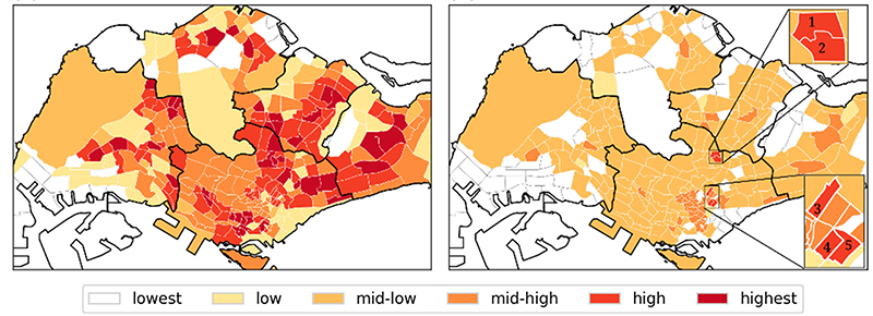 The coronavirus disease 2019 (COVID-19) has posed one of the greatest threats to global
public health, causing substantial economic, social and political disruption. Geospatial
networks with high centrality and transitivity, such as public transportations, leisure
and recreational spaces, and the workplace, are locations more susceptible to COVID-19.
In response to this epidemic, Singapore entered into an unprecedented lockdown in
April 2020, locally coined as “Circuit Breaker,” to curb the virus from spreading.
In this seminar, I will share our on-going project on assessing spatiotemporal vulnerability
of COVID-19 in Singapore. I will first present a spatiotemporal integrated vulnerability
model to characterize the variation of COVID-19 risk across space and time, incorporating
social, built, platial and human movement features known to influence disease transmission.
Analyses are conducted at the subzone level, the basic planning unit of Singapore.
Then, I will share the survey of the project on individuals’ risk perception and behavioral
change. Comparisons will be made for individual’s transition of places for different
types of activities, such as work, getting food, and shopping, across the time periods
of pre-COVID-19, during the Circuit Breaker, and early 2022. The survey will enhance
the spatiotemporal model and inform the practicability of a neighborhood travel corridor.
The coronavirus disease 2019 (COVID-19) has posed one of the greatest threats to global
public health, causing substantial economic, social and political disruption. Geospatial
networks with high centrality and transitivity, such as public transportations, leisure
and recreational spaces, and the workplace, are locations more susceptible to COVID-19.
In response to this epidemic, Singapore entered into an unprecedented lockdown in
April 2020, locally coined as “Circuit Breaker,” to curb the virus from spreading.
In this seminar, I will share our on-going project on assessing spatiotemporal vulnerability
of COVID-19 in Singapore. I will first present a spatiotemporal integrated vulnerability
model to characterize the variation of COVID-19 risk across space and time, incorporating
social, built, platial and human movement features known to influence disease transmission.
Analyses are conducted at the subzone level, the basic planning unit of Singapore.
Then, I will share the survey of the project on individuals’ risk perception and behavioral
change. Comparisons will be made for individual’s transition of places for different
types of activities, such as work, getting food, and shopping, across the time periods
of pre-COVID-19, during the Circuit Breaker, and early 2022. The survey will enhance
the spatiotemporal model and inform the practicability of a neighborhood travel corridor.
Yi-Chen Wang is an Associate Professor at the Department of Geography, National University of Singapore. She also holds a Visiting Associate Professor position in the Department of Parasitology, Taipei Medical University, Taiwan since 2017. She received the PhD degree from the University at Buffalo, State University of New York. Her research area broadly covers land use land cover change and spatial health. Her recent work on the neglected tropical disease – liver fluke infection – investigates land use, human behavior, and social dynamics as risk factors of foodborne parasitic infection in the Lower Mekong River Basin. Her current work extends into health and environment in the urban setting, to apply geospatial technologies in examining the relationship between the neighborhood characteristics of the environments and infectious disease risk and distribution.
Remote Sensing of the Atmosphere using GNSS Signals
Dr. Pawel Hordyniec
Assistant Professor
Institute of Geodesy and Geoinformatics
Wroclaw University of Environmental and Life Sciences, Poland
Visiting Researcher
Scripps Institution of Oceanography
University of California San Diego
Friday, October 7
3:30pm to 4:30pm
Storm Hall 316
GNSS remote sensing techniques emerged from strictly geodetic applications for the purpose of accurate determination of positions and motions of points on the Earth’s surface. The atmosphere is one amongst a variety of factors limiting the performance of GNSS satellite positioning. In order to achieve centimeter-level accuracy, the delay induced by non-vacuum properties of the atmosphere needs to be estimated and removed from observations through modeling based on external meteorological information. It turned out that what is considered an error by the geodetic community can be also viewed as a valuable observation for meteorology, which opened a broad range of GNSS applications beyond the scope of the three pillars of geodesy: (1) geokinematics, (2) Earth’s rotation and (3) the gravity field. The atmospheric refraction can be measured with a GNSS receiver from various platforms, including ground-based geodetic networks, remote sensing satellites and research aircrafts. The limb sounding with the GNSS radio occultation (RO) technique is one of the most innovative measurement concepts that significantly contributed to atmospheric and climate sciences due to global coverage and its high vertical resolution. The retrieved atmospheric profiles are often referred to as anchor observations as they require no bias correction before being introduced to weather models. However, the process of converting observation data to model variables requires sophisticated methods to resolve the problem of data assimilation. In this talk, various applications of GNSS atmospheric remote sensing will be demonstrated and main scientific challenges will be outlined.
Pawel Hordyniec is an Assistant Professor at the Institute of Geodesy and Geoinformatics, Wroclaw University of Environmental and Life Sciences, Poland. He received the Ph.D. in satellite geodesy from WUELS, Poland in 2019. He has been working as an Assistant Professor with his home institution since 2015. During multiple stays in 2014-2017 as a Visiting Scholar he has been cooperating with researchers from National Central University, Taiwan and the National Space Organization, Taiwan on the development of algorithms for inverting GNSS radio occultation signals in the neutral atmosphere. In 2018-2020 he was a Research Fellow at RMIT University, Melbourne, Australia focusing on meteorological forecasting and climate analysis over the Australian and Antarctic regions with the use of GNSS remote sensing techniques. Currently, he is also a Visiting Researcher at the Scripps Institution of Oceanography, University of California San Diego, USA working towards improving the forecast skill of atmospheric river events that contribute to long duration heavy precipitation and flooding on the U.S. West Coast. His research interests are focused on applications of GNSS signals for the remote sensing of the atmosphere using spaceborne observations and ground-based measurements as well as numerical simulation methods for studying anomalous propagation of radio signals.
Hunger, Survivance, and Imaginative Futures: A Racial Analysis of the “Right to Food”
Dr. Adam M. Pine
Associate Professor of Geography
University of Minnesota Duluth
Friday, October 28
3:30pm to 4:30pm
Storm Hall 119
A “Better Foods Future” Talk
 For the last half century, the “right to food” (RTF) framework has been promoted by
the United Nations as an important policy framework to end hunger. However, the RTF
assumes that countries view all of their population as worthy and deserving of food
security. Given the legacy of racism in the United States, racialized minorities have
not been viewed by the state as deservant of food security. Rather than work to support
food security for all, the state instead has used its power to create two food systems,
separate and unequal.
For the last half century, the “right to food” (RTF) framework has been promoted by
the United Nations as an important policy framework to end hunger. However, the RTF
assumes that countries view all of their population as worthy and deserving of food
security. Given the legacy of racism in the United States, racialized minorities have
not been viewed by the state as deservant of food security. Rather than work to support
food security for all, the state instead has used its power to create two food systems,
separate and unequal.
In this talk I explore how the U.S. government has used agricultural, food and nutrition, and urban planning policies to deny food to communities of color. Grounded in these historical patterns, I define equity principles to guide work on the racialized food system and I discuss six reparative public policies that will significantly decrease hunger and build political power in racialized communities: (a) repairing SNAP, (b) restoring food sovereignty, (c) revitalizing grocery stores, (d) reframing restaurants, (e) reconstituting food pantries, and (f) rebuilding communication sovereignty.
Dr. Pine is a human geographer (Ph.D. Rutgers) with teaching and research interests in urban policy, race, and the global food system. His principal research projects examine the relationship between white supremacy and US urban planning, the interconnections between housing precarity and food insecurity, and how anti-racist food activists are fighting to institute the right to food in the US.
Interdisciplinary and Data-Driven Approaches to Understanding Hydroclimatic Change
Dr. Morgan Levy
Assistant Professor
Scripps Institution of Oceanography
School of Global Policy and Strategy
University of California San Diego
Friday, November 4
3:30pm to 4:30pm
Storm Hall 316
Interactions between humans and water are mediated by complex social and physical dynamics. Thus, studying physical water systems in isolation is often not possible, and analysis of coupled systems can be challenging. For example, anthropogenic activities complicate the use of many traditional hydrologic modeling approaches by introducing non-stationarity and feedbacks. Considering this challenge, and the increased availability of spatiotemporal datasets, this talk will highlight the use of data-driven frameworks to understand interactions between geophysical water processes and human water use at multiple scales. Specifically, this talk will explore the impacts of hydroclimatic variability on inland and coastal surface water and groundwater availability in California. This research underscores the complexity and promise of using data-driven approaches to advance sustainable freshwater management and climate change adaptation.
Morgan Levy is an Assistant Professor in the Scripps Institution of Oceanography and the School of Global Policy and Strategy at the University of California, San Diego. She received a Ph.D. and M.S. in Energy and Resources, and a M.A. in Statistics from the University of California Berkeley. Her research focuses on understanding interactions between climate, terrestrial water systems, and environmental and human health at local to global scales. She uses methods from hydrology, ecohydrology, and applied statistics to do data-driven, policy-relevant research that connects climate to environmental and human health through water cycle processes.
Water Quality in Agricultural Landscapes: Ireland’s Agricultural Catchment Programme
The Lauren C. Post Memorial Lecture
Dr. Daniel Hawtree
Research Officer
Teagasc - Agricultural Catchment Programme
Adjunct Associate Professor
School of Biomolecular and Biomedical Science
University College Dublin, Ireland
Friday, November 18
3:30pm to 4:30pm
Storm Hall 316
The Agricultural Catchment Program (ACP) is a program initiated in Ireland in 2008 to monitor and assess the efficacy of measures put in place to protect water quality. To this end, a set of catchments were selected which represent a range of the most common agricultural and site conditions in Ireland, where long-term sampling stations could be established in cooperation with local farmers. At these sites, key variables are collected at high temporal resolution (e.g., 15-minutesampling time), which has provided a substantial trove of data on the hydrologic and nutrient dynamics in these catchments. Modelling efforts are now underway using these datasets to improve our capacity to predict future hydro-chemical fluxes under changing conditions, and to simulate alternate potential scenarios designed to meet Ireland’s obligations under EU regulations on agriculture and water quality. This seminar will provide an overview of the ACP and the current modelling work being undertaken, as well as touching on the other key components of the program (e.g., gaseous emissions, knowledge transfer, education).
Daniel Hawtree is a research officer at Teagasc (the Irish national body responsible for research, advisory, and training services to the agri-food industry) and an Adjunct Associate Professor at University College Dublin. At Teagasc, his research is focused on developing catchment models within the Agricultural Catchment Programme. Daniel is a native of San Diego and received both his BSc (Psychology) and MSc(Geography) at San Diego State University, which was then followed by a research internship at the European Commission Joint Research Centre (Ispra, Italy), and then a joint PhD split between Technische Universität Dresden and University of Padua. Since 2018, Daniel has been based in Ireland, where he carried out post-doctoral research at University College Dublin, before moving to Teagasc in 2021.
What Do We Lose When We Lose a Biome?
Dr. Bernardo A. Bastien-Olvera
Postdoctoral Scholar
Scripps Institution of Oceanography
Friday, January 27
3:30pm to 4:30pm
Storm Hall 316
The effects of climate change on natural systems will be substantial, widespread,
and likely irreversible. Warmer temperatures and changing precipitation patterns have
already contributed to forest dieback and pushed some species toward extinction. Natural
systems contribute to human welfare both as an input to the production of consumption
goods and through the provision of nonuse values (i.e., existence and bequest values).
But because they are often unpriced, it can be difficult to constrain these benefits.
Understanding how climate change effects on the natural capital stock affect human
well-being, requires understanding not just the biophysical effects of climate change
but also the particular role they play in supporting human welfare. This talk presents
a framework to think about this question and applies it to global projections of climate-driven
biome range shifts throughout this century.
Bernie is a geographer at the Scripps Institution of Oceanography researching how ecosystems react to climate change and how this will affect different societies worldwide. Interested in bridging process-based ecological dynamics and the multiple value systems that underlie human-nature relations to explore possible mitigation and adaptation strategies to climate change.
Climate Change Impacts and Opportunities for California’s Natural and Working Lands: The Role of the USDA Climate Hubs
Dr. Steven Muir Ostoja
Director
USDA California Climate Hub
Agricultural Research Service Fellow
The Muir Institute of the Environment
University of California, Davis
Friday, February 17
3:30pm to 4:30pm
Storm Hall 316
A “Better Foods Future” Talk
Steven Ostoja will overview the mission of the USDA Climate Hub to enable climate information decision making for farmers, ranchers and foresters to ensure resilience for the state's natural and working lands, and discuss opportunities for engagement and collaboration for students and faculty.
Steven will also share findings from USDA California Climate Hub projects regarding the impacts of wildfire on wine grapes, extreme heat events on high value perennial crops like citrus and almonds, and what climate change in terms of warmer and dryer conditions might mean for the future of farming in the largest agricultural producing state in the nation.
Dr. Ostoja's research interests include applied natural resources management, human- environment interactions, and climate adaptation science. His work has been published in over 50 peer-reviewed, government and technical publications and has contributed to numerous popular media outlets. As Director of the California Climate Hub, Dr. Ostoja leads the development and delivery of regional, science-based information that enables climate-smart agricultural and forestry decision-making for natural and working lands for the largest state in the nation. When not running the California program, you will find Dr. Ostoja either on a mountain bike trail, running white water rivers or paddle surfing.
Improving Disaster Response Through UAS Imaging and Analysis, Artificial Intelligence, and Timeliness Assessment
Dr. Andrew C. Loerch
Senior GIS Analyst
Quartic Solutions
Co-founder
ChangeAerial
Friday, February 24
3:30pm to 4:30pm
Storm Hall 316
Aerial imaging is a useful tool for emergency management and response but poseschallenges in maximizing its effectiveness. The challenges include information quality, accuracy, and the timeliness of information delivery. This research associated with my doctoral dissertation builds upon the Remote Sensing Communication Model (RSCM) to configure an end-to-end time-sensitive remote-sensing-system based on uncrewed aerial systems (UAS) and machine-learning-based damage detection. UAS with different navigation capabilities were tested with repeat station imaging (RSI) and traditional imaging approaches at sites representing critical infrastructure at San Diego State University. Utilizing navigation corrections, the UAS flown with the RSI method was shown to have more accurate repeated navigation to camera stations and multi-date image pairs with the RSI method are shown to have lower image co-registration errors. A deep machine-learning model evaluated on two-date layer-stacked images detected damage (cracks) with a higher accuracy when applied to RSI images rather than those captured in a more ad hoc fashion. Customized deep-learning models were evaluated using the RSI images, with the best-performing model achieving 98.4% overall accuracy. These research findings document the potential for integration of UAS, RSI image capture and registration and deep learning damage detection models for post-hazard assessment of damage to critical infrastructure.
Dr. Andrew C. Loerch has a PhD in Geography from the SDSU and UCSB Joint Doctoral Program. His research has focused on remote sensing, software development and machine learning. His refereed publications include research in repeat station imaging for volumetric mapping, environmental monitoring and the use of artificial intelligence for detecting damage to critical infrastructure after disasters.
Projecting Extreme Droughts in Rapidly Changing Human-Water Systems Across the UK
Dr Gemma Coxon
Senior Lecturer in Hydrology
University of Bristol, England
Friday, March 10
3:30pm to 4:30pm
Storm Hall 316
A reliable water supply is often taken for granted in the UK. However, decreasing water supply from anthropogenic climate change, coupled with increasing water demand from a growing population are projected to lead to frequent water shortages across the UK by 2050. This seminar will present recent advances in national-scale drought modelling and our understanding of human influences on river flows using a unique dataset of spatially explicit, time-varying abstractions and discharges across the UK. It will also look ahead to discuss how we can ensure a resilient UK water supply for the future.
Dr. Gemma Coxon is a senior lecturer at the University of Bristol and a UKRI Future Leaders Fellow. Her research focuses on understanding and predicting floods and droughts in changing environments through the simulation of water systems from local to continental scales. Gemma and her team work closely with communities, water companies, and regulatory bodies across the UK, and are currently involved in projects on (1) delivering a £38M large-scale investment in flood and drought research infrastructure in the UK (2) informing the development of new water supply infrastructure and (3) projecting extreme droughts in rapidly changing human-water systems.
A Few Hundred Catchments Later – Lessons Learned From Modeling Large Catchment Samples
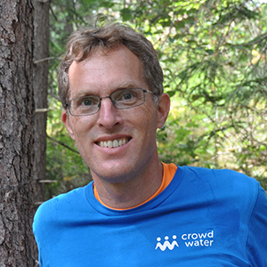
Dr. Jan Seibert
Professor of Geography
University of Zurich, Switzerland
Friday, March 17
3:30pm to 4:30pm
Storm Hall 316
Hydrological models have traditionally been applied to a few catchments, since the preparation of input data for a larger set of catchments is challenging. However, the availability of data sets with hydro-meteorological time series for large numbers of catchments has been a game changer. An example is the CAMELS data set with more than 600 U.S. catchments, for which basic data to run hydrological models has been made readily available. In recent studies, we used such data sets for bucket-type modeling of catchments in different regions. Here, I will discuss some of our main findings:
Simulation results can vary greatly between catchments, making large catchment samples a prerequisite for robust results. Results indicate that even when applied uncalibrated, simple bucket-type models can provide surprisingly good results for some catchments. This needs to be considered when we assess model performance. On the other hand, it can be challenging to improve simulations for ungauged catchments by regionalization as it is not apparent how to find the most suitable donor catchments.
Large samples of catchments also allow us to evaluate the value of different data types. A limited number of streamflow gaugings and other data types, such as stream levels, can be informative for streamflow simulations. We further extended this approach to our citizen science project, CrowdWater, and could demonstrate that data collected using so-called virtual staff gauges can be valuable for streamflow simulations.
Dr. Seibert’s main research interest is hydrological modeling at different scales in combination with experimental studies. Current research topics include the use of catchment models for land-use and climate change impact studies, runoff generation processes and topography, uncertainty analysis and risk assessment, the value of different types of data and opportunities for citizen science in hydrology. His research has so far resulted in more than 200 peer-reviewed journal publications.
Uses of Remote Sensing in Geology
Dr Rafael Almeida
Assistant Professor of Geology
San Diego State University
Friday, April 14
3:30pm to 4:30pm
Storm Hall 119
American Society of Photogrammetry and Remote Sensing
Pacific Southwest Region
Spring Technical Meeting Plenary
This lecture will first provide an overview of geological problems that can be addressed with the use of remote sensing techniques. After this overview, we will focus on the catastrophic fluvial erosion taking place in the Coca River of Ecuador. On February 2, 2020 the largest waterfall in Ecuador, the San Rafael Waterfall with a height of ~150 m catastrophically collapsed, initiating a process of headward erosion that has wiped out one of the main roads in the eastern part of the country, tons of the main pipelines that transport crude oil from the field in the east to the ports on the Pacific coast, and threatens the largest hydropower plant in the country. The river is located in the Amazon foothills, with dense forest and cloud cover that hinders the use of many remote sensing techniques for its study. I will cover what we have been able to do to study this destructive natural process using drones and radar images, as well as what remains to be done to better describe this process.
Rafael Almeida is originally from Venezuela where he graduated from the Universidad de Los Andes as a Geological Engineer. He went on to do a master’s at Texas A & M University and a PhD at Columbia University. He worked as a researcher at the Earth Observatory of Singapore and then as faculty at Yachay Tech University in Ecuador. He has been part of the SDSU faculty at the Department of Geological Sciences for the last 2 years. He has worked on the geology of the western US, the Andes of Venezuela, Ecuador and Argentina, and the Himalaya system of Nepal and Bangladesh.
Imagining a Food System that Belongs to All of Us
Sona Desai
Co-Executive Director
San Diego Food Systems Alliance
Friday, April 21
3:30pm to 4:30pm
Storm Hall 316
A “Better Foods Future” Talk
San Diego County Food Vision 2030 is a shared vision, plan, and movement for transforming our region’s food system over the next ten years. With three goals, ten objectives, and detailed strategies to inform policy, program, planning, and investment opportunities, Food Vision 2030 serves as a call to action and political compass as we work together toward a more equitable and resilient future for all.
Food Vision 2030 was published by the San Diego Food System Alliance in the Summer of 2021, and is the work of many people. 3,000 residents of San Diego County—a majority of whom have been deeply impacted by inequities—voiced their needs and aspirations for the food system and provided essential input on the Vision.
Please join Sona Desai to learn more about the San Diego County Food Vision 2030 planning process and how we can work together to imagine a food system that belongs to all of us.
Sona Desai is Co-Executive Director of the San Diego Food System Alliance. Sona has been working to advance sustainable and equitable food systems for more than 20 years. She has a background in organic farming, food marketing and distribution, farm business development, and is recognized nationally as a leader in food hub and community food systems development. Before joining the San Diego Food System Alliance, Sona was the Director of Food Systems Development at the Leichtag Foundation where she provided thought leadership, research, and food and farm based consulting services to advance the Foundation’s food system strategy. She also served as the Associate Director of Coastal Roots Farm in Encinitas. As the Co-Executive Director of the San Diego Food System Alliance, Sona provides strategic and management support for the organization, strengthens support services for small-scale sustainable food producers and fishermen in the region, provides consulting services to advance economic development in the food system and leads diversity, equity and inclusion efforts.
Portraying Genocide through the Eyes of Children: The Troubled Geographies of Authenticity in Loung Ung’s “First They Killed My Father: A Daughter of Cambodia Remembers”
Dr. James A. Tyner
Professor of Geography
Kent State University
Friday, April 28
3:30pm to 4:30pm
Storm Hall 316
On April 17, 1975 soldiers of the Communist Party of Kampuchea (CPK), better known as the Khmer Rouge, entered Cambodia’s capital city of Phnom Penh. Within hours, heavily armed cadre—many of whom were themselves child-soldiers—began forcibly evacuating the city. For many men, women, and children—including a young girl named Luong Ung—this day marked the beginning of the Cambodian genocide. Such is the narrative of the 2017 Netflix film First They Killed My Father: A Daughter of Cambodia Remembers. Directed by Angelina Jolie, the film hews closely to Loung Ung’s 2000 autobiography of the same name. Written as an adult, Ung’s memoir received much acclaim and was a national bestseller. Indeed, while Ung’s narrative is among several memoirs published by Cambodian American survivors of the genocide, it has—with the exception of Ngor’s autobiography—received by far the most notoriety. To date, significant attention has focused both on Ung’s memoir and its cinematic sibling. In my presentation I contribute to conversations but do so in an attempt to place genocide studies in dialog with the subfield of children’s geographies. Ung’s filmic depiction of her everyday experiences of surviving genocide raises several concerns that coalesce around the struggle to articulate and authenticate the unimaginable. And yet, through the prism of Ung’s childhood eyes, a world of unthinkable horrors comes into focus and with it, an expository clarity that transcends a simple dichotomy of authentic and in-authentic.
James Tyner is Professor of Geography at Kent State University and a Fellow of the American Association of Geographers. He received his PhD in Geography from the University of Southern California. Professor Tyner is the author of more than twenty books, including War, Violence, and Population, which received the AAG Meridian Book Award for Outstanding Scholarly Contribution to Geography. In addition, Professor Tyner is the recipient of the AAG Glenda Laws Award for outstanding contributions to geographic research on social issues. His research coalesces around violence, genocide, militarism, and political economy.
Dissertation Presentations
Improving Disaster Response With Aerial Imagery Through UAS-Based Image Acquisition
and Analysis, Artificial Intelligence, and Timeliness Assessment
Andrew C. Loerch
Tuesday, September 9, 2022
9:00 am to 10:00 am
Zoom Session
El Salvador in Motion: Socioeconomic Causes of Child Migration
Elizabeth Kennedy
Friday, November 18, 2022
10:00 am to 11:00 am
Zoom Session
Understanding Human Mobility and Urban Dynamics with Big Geospatial Data Analytics
Chanwoo Jin
Friday, December 2, 2022
3:00 pm to 4:00 pm
Zoom Session
Pyro-geography of California: A Study of Wildfire-Climate Dynamics
David Rother
Monday, April 17, 2023
1:00 pm to 3:00 pm
Zoom Session
Spatial and Temporal Assessment of Regional Crime
Crystal English
Wednesday, May 3, 2023
2:00 pm to 4:00 pm
Storm Hall 325 and Zoom Session
Thesis Presentations
Living in the Animal/Human Borderland: Human-Macaque Relationships in Chitwan, Nepal
Yanjing (Tracy) Liu
Friday, September 2, 2022
1:00pm
Zoom Session
The Role of Narrow Cold Frontal Rainbands on Urban Flooding in Southern California
Justin Tang
Thursday, September 29, 2022
9:00am
Zoom Session
Are Deep Learning Models up to the Challenge of Predicting Flow in Semi-Arid Watersheds?
Emily Deardorff
Monday, December 5, 2022
8:30am
Storm Hall 325 and Zoom Session
Machine Learning Approach to Burned Area Mapping for Southern California
Chandler Ross
Friday, March 10, 2023
11:00am
Zoom Session
Mapping Tree and Shrub Density on Pastures in the Southwestern Amazon
Mallorie Honey
Thursday, April 27, 2023
10:00am
Storm Hall 325 and Zoom Session
Characterizing Changes in Wetland Habitat Using Multi-Decadal Satellite Imagery
Margot Mattson
Monday, May 1, 2023
1:00pm
Storm Hall 339
Independent Data Validation to Detect Biases in Synthetic Populations
Jessica Embury
Tuesday, May 2, 2023
1:00pm
Storm Hall 339
Exploring Participatory Methods and Surveys Through a Critical Perspective in La Mesa’s
Child-Friendly Cities Project
Phevee Paderes
Thursday, May 4, 2023
10:00am
Storm Hall 325 and Zoom Session
Exploring Smallholder Farmers Perceived Climate-Related Risk, Impact, and Response
in the Dry Corridor of El Salvador
Daniel Ochoa
Monday, May 15, 2023
3:00pm
Storm Hall 325
Mapping Plastic in an Urban Watershed Using Laboratory Reflectance Spectroscopy and
WorldView-3 SWIR Imagery
Elena Aguilar
Friday, June 9, 2023
10:00am
Zoom Session
Integration of Geomorphic Data in Manual and Semi-Automated Benthic Habitat Mapping
of a Hawai’ian Fringing Reef
Liana Heberer
Monday, June 12, 2023
2:00pm
Zoom Session
A Hydrologic Signature Approach to Analyzing Wildfire Impacts on Overland Flow
Lauren Bolotin
Monday, June 26, 2023
3:00pm
Zoom Session
Identifying Culturally Significant Marine Species and Habitats in San Diego, CA
Christina Garvey
Wednesday, July 26, 2023
10:00am
Storm Hall 325 and Zoom Session
General Events
2023 Climate Talks
Native Climate Sciences: (Re)turning the Gaze on Invasive Species of Thought
Presented by the Geography Graduate Student Association
Monday, April 10
3:00 - 6:00pm
Aztec Student Union Theater
Reception to follow
This student-led project, through the Geography Graduate Student Association (GGSA), will focus on bringing together Indigenous leaders and traditional practitioners to provide much-needed perspectives, practices, and wisdom—and the associated challenges Indigenous communities may be facing–related to colonial—and industrial-induced climate change. The purpose is twofold: (1) to provide a forum for Indigenous insights, concerns, and lessons to challenge blind-spots, errors, and exclusions of Western climate science, and (2) to present SDSU students, faculty, staff, alumni, and the wider public with opportunities to become worthy to responding to these challenges.
Panel moderated by Shasta Gaughen and Giorgio Hadi Curti
Panelists:
- Michael Connolly Miskwish, The Kumeyaay Nation
- Edward Wemytewa, The Zuni Tribe
- Dr. Ora Marek-Martinez, The Navajo Nation
- Tino Villaluz, The Swinomish Tribe
- Daranda Hinkey, The Fort McDermitt Paiute-Shoshone Tribe
Visit the GGSA website to find out more information and to register for the 2023 event.
American Society for Photogrammetry and Remote Sensing Pacific Southwest Region Spring Technical Meeting
Presented by the SDSU Student Chapter of ASPRS
Friday, April 14
1:30 to 4:30pm
Storm Hall 119
Reception to follow
Please join the American Society for Photogrammetry and Remote Sensing (ASPRS) Pacific Southwest (PSW) Region and San Diego State University (SDSU) Student Chapter of ASPRS on Friday, April 14th, 2023 for our Spring Technical Meeting.
Speakers:
- 2:00 to 2:30: Jeremiah "J" Chaplin (Planet) - Career Trajectory and Skysat Imagery
- 2:30 to 3:00: Dr. Kellie Uyeda (Tijuana River National Estuarine Research Reserve) - Monitoring Habitat Change in the Tijuana River Valley
- 3:00 to 3:30: Tim Haynie (Spectrabotics) - Data Science for Every GIS Professional: How AI Will Clear the Fog of Sensor Analysis
- 3:30 to 4:30: Plenary Speaker Dr. Rafael Almeida, Assistant Professor of Geology, SDSU - Uses of Remote Sensing in Geology
There will be time following the presentations for additional Q&A from 4:30-5:30 pm during a reception in the Geography Department, Storm Hall 312. This will be a great event to learn about current remote sensing, photogrammetry, and GIS research projects and opportunities. We hope you can join us!
Geography and Urban Studies Graduation Ceremony
Friday, May 12
10:00am
Exercise and Nutritional Sciences 280
Please join the Department of Geography and Urban Studies as we celebrate our graduates. There are no tickets required for the Departmental ceremony.
Colloquia Series
Human-Watershed Interactions: from the Amazon to the US-Mexico Border
Dr. Trent Biggs, Professor of Geography, San Diego State University
Friday, September 17, 2021
3:30 pm to 4:30 pm
Zoom Link: https://sdsu.zoom.us/s/86108452784
Meeting ID: 861 0845 2784
Passcode: 92182
How do humans impact watersheds, including their water quantity and quality? What processes drive those impacts, and what are the consequences for humans and ecosystems? Finally, how can we combine remote sensing, modeling and field observations to understand human-watershed interactions? This talk will address these questions with examples from the Amazon and US-Mexico border, including a summary of work by SDSU faculty and students over the past 20+ years.
Trent W. Biggs’ research interests include the impacts of land use on hydrology, water quality, and sediment. Dr Biggs and his students use satellite imagery, fieldwork, and modeling to diagnose and analyze water-related problems that impact the environment and human welfare. His field locations include American Samoa, southern India, the Himalaya, and the US-Mexico border region. Most recently he and a team of students have analyzed the environmental consequences of urbanization on the US-Mexico border, with an emphasis on the origins of sediment that has damaged local estuaries.
The $16 Taco: Contested Geographies of Food, Ethnicity, and Gentrification
Dr. Pascale Joassart-Marcelli, Professor of Geography, San Diego State University
Friday, October 8, 2021
3:30 pm to 4:30 pm
Zoom link: https://SDSU.zoom.us/j/81442477084
Meeting ID: 814 4247 7084
Passcode: 92182
Barbacoa tacos, bibimbap, bánh mi, pupusas, and other “authentic ethnic” foods are drawing white, middle-class, and college-educated eaters into historically segregated neighborhoods where residents, mostly people of color and immigrants, have long struggled with limited food access. Does this signal the emergence of a more inclusive city?
The $16 Taco focuses on the role of food in transforming urban landscapes. Drawing on extensive field work in San Diego, Pascale Joassart-Marcelli documents the evolution of Barrio Logan, City Heights, and Southeastern San Diego’s foodscape away from serving the needs of long time minoritized residents to pleasing the tastes of wealthier and whiter newcomers. She shows how this trend—fueled by media attention and capitalized on by developers—contributes to gentrification and the displacement of the very people who have produced these foodscapes through self-reliance in the face of food apartheid. Her research illustrates how food can both emplace and displace immigrants, shedding light on the larger process of gentrification and the emotional, cultural, economic, and physical displacement it produces.
Pascale Joassart-Marcelli is Professor of Geography and Director of the interdisciplinary Food Studies and Urban Studies programs at San Diego State University where she has been teaching courses such as Geography of Cities, Geography of Food, Food Justice, Feeding the World, and Food, Place,and Culture. Her research focuses on the relationship between place, ethnicity, and food, including the role of food in creating just and sustainable cities for all. She has published over 50 peer-reviewed articles and book chapters, is the author of The $16 Taco: Contested Geographies of Food, Ethnicity, and Gentrification (2021) and the co-editor of Food and Place: A Critical Exploration (2018). Her research has been funded by the National Science Foundation and other private and public funding agencies.
Geography as Brick: Joyfully Fracturing the Ecology of Negligence and Inattention of the Cultural/Natural Resources Management Industrial Complex through Critical Geographies and Geo-Philosophies (with special focus on NHPA, NEPA, and CEQA)
Dr. Giorgio H. Curti, Co-Owner and Project Director, Cultural Geographics Consulting, LLC, Adjunct Professor and Lecturer, Department of Geography, SDSU
Friday, October 22, 2021
3:30 pm to 4:30 pm
Zoom link: https://SDSU.zoom.us/j/85362926100
Meeting ID: 853 6292 6100
Passcode: 92182
Laws and regulations that guide environmental, heritage and cultural resource, and historic preservation in the United States—such as the National Historic Preservation Act (NHPA), National Environmental Policy Act (NEPA), and California Environmental Quality Act (CEQA)—ostensibly, in their stated intents and purposes, exist to serve the concerns, interests, and health and well-being of the multitude. Whatever the intentions of their promulgations, these laws have been found to be largely procedural by the courts. In practice, procedural implementations of these laws are overwhelmingly dominated by what can best be characterized as an ecology of governmental negligence and professional ultracrepidarian gatekeeping. This dominant and dominating symbiosis of carelessness and inattention defines the cultural/natural resources management industrial complex and often renders any semblance of compliance to empty and inattentive processes of hollow box-checking and limited disciplinary (mis)interpretations. This, in turn, works as regulatory capture through horizontal means. The dire effects on integral material, embodied, and relational capacities of communities and environments—particularly Native communities and their traditional cultural places and landscapes—are at best treated as matters that can be “mitigated” by so-called “subject matter experts” and at worst (and as is most common) realities to ignore, deflect, neglect or even actively veil, bury, and silence. This talk explores how spectrums and bricks of attentive geographical thought and practice—particularly those advanced by critical geographies (broadly understood) and geo-philosophies—offer pragmatic, inclusive, collaborative, corrective, and productive ways of joyfully fracturing and creatively re-fashioning circuits of the procedures that guide NHPA, NEPA, and CEQA compliance—to and for the benefits of the multitude.
Giorgio Hadi Curti is a socio-cultural geographer and critical ethnographer who works at the intersections of cultural and natural resources laws and mandates, traditional and local knowledges and sciences, and the collaborative development and implementation of land and water stewardship and management strategies guided and defined by Native and traditional communities and associated human-environment relationships, cosmologies, and worldview and value systems. Giorgio received his PhD in 2010 from the San Diego State University-University of California, Santa Barbara Geography Joint Doctoral Program. In 2016, Giorgio and friend and fellow SDSU-UCSB Joint Doctoral alum, Christopher Moreno, founded Cultural Geographics Consulting (CGC), a minority-owned small business that pursues ontological and epistemic justice in its dedicated mission to help create a world where historically and geographically marginalized peoples are empowered to define and direct their own futures. In addition to his work with CGC, Giorgio serves as Adjunct Professor and Lecturer in the SDSU Department of Geography, and as a Research Associate with the Young People’s Environments, Society and Space Research Center.
When All Models Are Wrong: A Recipe for Spatial Sensitivity Analysis
Dr. Seda Şalap-Ayça, Lecturer of Geosciences, University of Massachusetts Amherst
Friday, November 12, 2021
3:30 pm to 4:30 pm
Zoom link: https://SDSU.zoom.us/j/87589102401
Meeting ID: 875 8910 2401
Passcode: 92182
Descriptive and predictive spatial models are potentially important tools in aiding decision-making, providing that the reliability of their results is accounted for, explained, and properly communicated to model users. However, all process representations in spatial models are subject to uncertainty. Therefore, the question becomes how to understand the unknown (uncertainty) of the unknowns (the model parameters). As a solution to this problem, a spatial model’s reliability can be assessed by quantifying and representing model output uncertainty followed by sensitivity analysis (SA). Uncertainty analysis (UA) quantifies the model uncertainty and SA enables exploring the space of input factors to find out which contributes the most to the error and uncertainty in modeling. In this talk, I will demonstrate a generic recipe for UA-SA for spatial models, followed by representative examples for a land-use evaluation and a land-use forecasting model. And at the final step, the methods of visualizing the result of the integrated UA-SA framework will be examined by questioning their effectiveness on the end-users.
Seda Şalap-Ayça, has a BSc from Mining Engineering with a double minor in GIS and Remote Sensing. After her MSc in Geodetic and Geographic Technologies, she completed the Joint Doctoral Program in Geography at SDSU and UC Santa Barbara, where she specialized in spatial decision making, land-use models, uncertainty and sensitivity analysis for spatial models, and visualization of spatial model outputs. Currently, she is a lecturer at UMass, Amherst at Mt Ida Campus, where she teaches various levels of GIS courses in hybrid mode. Her current collaborative research project focuses on assessing social vulnerability and understanding the flood risk factors in Massachusetts.
The State of the Map: Transforming Geospatial Information
Julie Sweetkind-Singer, Associate University Librarian for Science and Engineering Resources, Head, Branner Earth Sciences Library & Map Collections, Stanford University
Friday, November 19, 2021
3:30 pm to 4:30 pm
Zoom link: https://SDSU.zoom.us/j/82865456753
Meeting ID: 828 6545 6753
Passcode: 92182
Today’s technologies allow people to use geospatial information in a variety of ways. This talk will explore how data trapped on paper maps are being transformed into actionable information, how satellite imagery is being used to affect health outcomes, and how historical maps interact with imagery to compare the past with the future.
Julie Sweetkind-Singer is the Associate University Librarian for the Science and Engineering Resources Group in the Stanford Libraries. She oversees the staff and support infrastructure provided to the faculty, researchers, and students for the cartographic and geospatial programs centered within the Libraries, including the Branner Earth Sciences Map Collections, the Stanford Geospatial Center, and the David Rumsey Map Center. Julie served for six years on the National Geospatial Advisory Committee (2014-2019, Chair: 2016-2018), an Advisory Committee to the FGDC. She currently sits on the User Working Group for SEDAC, the Socioeconomic Data and Applications Center at Columbia University.
From Psychology to Sustainability: How Bikes and Scooters Can Reshape Urban Mobility
Dr. Dillon Fitch, Co-Director, BicyclingPlus Research Collaborative, Institute of Transportation Studies, University of California, Davis
Friday, December 3, 2021
3:30 pm to 4:30 pm
Zoom link: https://SDSU.zoom.us/j/81594779978
Meeting ID: 815 9477 9978
Passcode: 92182
Integrating my recent research, I will discuss how individual-level bicycling attitudes and behavior demonstrate opportunities for reducing automobility. Using psychological experimentation, travel surveys, and GIS/GPS data to understand travel behavior, I focus my analysis on environment-behavior interactions in a variety of Californian urban contexts. I will discuss the role of local and state planning and policy in shaping those interactions and suggest ways to leverage bikes, electric bikes, electric scooters, and future micro-modes to improve transportation sustainability.
Dillon Fitch is the Co-Director of the BicyclingPlus Research Collaborative at the Institute of Transportation Studies, UC Davis. His research focuses on bridging disciplines and institutions in studying bicycle mobility and emerging forms of micromobility. His recent published work spans travel behavior and transportation planning, and has current projects on micromobility service impacts to car use and the evaluation of bike/pedestrian project benefits among others. Dillon received a BA in Political Science from UC Irvine, MS in Geography from San Diego State, and PhD in Transportation Technology and Policy from UC Davis.
Adapting to Environmental Change: Strategies for West Coast Shellfish Growers
Dr. Melissa Ward
Postdoctoral Researcher
Dept. of Geography and Coastal Marine Institute
San Diego State University
Friday, February 4, 2022
3:30 pm to 4:30 pm
Zoom Link: https://SDSU.zoom.us/j/89421546229
Meeting ID: 894 2154 6229
Passcode: 92182
The shellfish aquaculture industry along the West Coast is particularly vulnerable to ocean acidification (OA), given the negative effects of low pH on shellfish survival and growth. The social-ecological system exemplified by this industry serves as an opportunity to identify and address strategies for local adaptation. Through interviews conducted with West Coast shellfish growers, we find that growers are concerned about OA, among many other environmental stressors such as marine pathogens and water temperature. However, growers are often unable to attribute changes in shellfish survival or health to these environmental factors due to a lack of data and the resources and network required to acquire and interpret these data. From these interviews, we identify a list of adaptive strategies growers employ or would like to employ to improve their overall adaptive capacity to multiple stressors (environmental, economic, political), which together, allow farms to weather periods of OA-induced stress more effectively. In particular we explore the challenges, potential benefits, and science surrounding one adaptive strategy – co-locating shellfish aquaculture with eelgrass. We present recent work suggesting that eelgrass can elevate local pH, positively impacting co-located shellfish. However, implementing such a strategy comes with environmental and management challenges, which we explore here.
Melissa Ward received her PhD from the SDSU-UC Davis joint-doc program in Ecology and is currently a postdoctoral researcher at San Diego State University. Her research explores natural climate solutions, focusing on the biogeochemical processes associated with coastal carbon cycling and on understanding how human communities can adapt to climate change. Specifically, Melissa’s current work investigates the ways in which shellfish aquaculture growers can adapt to ocean acidification, and how seagrass might facilitate or challenge this adaptation.
AAG Prep and Pep Talks
![]()
Friday, February 18, 2022
3:30 pm to 4:50 pm
Zoom Link: https://SDSU.zoom.us/j/88597794644
Meeting ID: 885 9779 4644
Passcode: 92182
A preview of presentations that SDSU Geography students will give at the upcoming Annual Meeting of the American Association of Geographers. Presenters will have a chance to practice their presentations and receive valuable feedback
- Ettore Asoni, Scales of foreignness: US immigration law as a geographic and constitutional abnormality
- Jessica Embury, The Dynamic Roles of Chronic Disease, Socioeconomic Factors, and Mobility on Population Vulnerability During the COVID-19 Pandemic
- Gabriela Morales, Agricultural Responses to Changing Water Supplies in Imperial Valley, California
- Jake Rowlett, “Between Fantasy and Reality:” Star Wars and the Adaptation of Cinema into Themed Attractions
Moderator: Corrie Monteverde
Coordination: Dan Grafton
AR4D and the Life Geographic
Dr. Steven Prager
Principal Scientist for Climate Resilient Food Systems
Climate Action
International Center for Tropical Agriculture
Alliance of Bioversity International and CIAT
Cali, Colombia
Friday, March 4, 2022
3:30 pm to 4:30 pm
Zoom Link: https://SDSU.zoom.us/j/81784130249
Meeting ID: 817 8413 0249
Passcode: 92182
AR4D is shorthand for “Agricultural Research for Development”. All around the world there are dedicated individuals working to improve the livelihoods of smallholder agricultural producers and the environments on which those livelihoods (and lives) depend. AR4D covers an incredible gamut of topics from understanding the sustainability of food systems to improving crop varieties to developing highly tailored and locally adapted approaches for “climate smart agriculture”. In nearly every aspect of the AR4D process, geographers have the potential play an important role in helping smallholders adapt to the challenges presented by climate change, ever increasing globalization, and the changing food system.
In this talk, we will cover a range of AR4D-realted themes and discuss where geographers fit into this important area of research and practice. Whether one is interested in understanding and scaling equity in access to markets and agricultural technology or in improving seasonal agro-climactic forecasts for a specific region, understanding geography, geographic theory, and geographic information are critical. At the same time, “selling geography” is not always easy, and entry points for geographers into the AR4D world are not necessarily obvious. As such, in addition to considering a variety of different potential research areas, this talk will also address how to prepare oneself for an AR4D career or related scientific collaboration.
Steven Prager is a Principal Scientist for Climate Resilient Food Systems, based at the International Center for Tropical Agriculture (CIAT), in Cali, Colombia. There, Steve has led major contributions to the recently concluded CGIAR Global Futures and Strategic Foresight research activity, and a portfolio of projects related to the development of climate services and digital adaptation approaches for agriculture development. At CIAT, Steve works to facilitate more informed decision-making in a broad range of areas from investments in agricultural research to agriculture management practices, all with an eye toward supporting improved adaptation and mitigation strategies. Steve specializes in the use of decision-science and quantitative foresight approaches and leads a team of highly skilled geographers, data scientists, and modelers specializing in crop, climate and bioeconomic processes. Prior to joining CIAT, Steve was an Associate Professor of Geography at the University of Wyoming where he conducted research and taught in the area of Geographic Information Science. Steve brings a diverse educational background to his CIAT research program with a B.S. in earth science and an M.A. in geography both from the University of North Carolina at Charlotte. He received his PhD in Geography from Simon Fraser University in 2002 where he studied the sustainable development through a lens at the interface between economic activity and the throughput of environmental goods and services.
Postponed
Water Quality in Agricultural Landscapes: Ireland’s Agricultural Catchment Programme
Dr. Daniel Hawtree
Research Officer
Teagasc - Agricultural Catchment Programme
Adjunct Associate Professor
School of Biomolecular and Biomedical Science
University College Dublin, Ireland
Postponed: To be rescheduled.
The Agricultural Catchment Program (ACP) is a program initiated in Ireland in 2008 to monitor and assess the efficacy of measures put in place to protect water quality. To this end, a set of catchments were selected which represent a range of the most common agricultural and site conditions in Ireland, where long-term sampling stations could be established in cooperation with local farmers. At these sites, key variables are collected at high temporal resolution (e.g., 15-minutesampling time), which has provided a substantial trove of data on the hydrologic and nutrient dynamics in these catchments. Modelling efforts are now underway using these datasets to improve our capacity to predict future hydro-chemical fluxes under changing conditions, and to simulate alternate potential scenarios designed to meet Ireland’s obligations under EU regulations on agriculture and water quality. This seminar will provide an overview of the ACP and the current modelling work being undertaken, as well as touching on the other key components of the program (e.g., gaseous emissions, knowledge transfer, education).
Daniel Hawtree is a research officer at Teagasc (the Irish national body responsible for research, advisory, and training services to the agri-food industry) and an Adjunct Associate Professor at University College Dublin. At Teagasc, his research is focused on developing catchment models within the Agricultural Catchment Programme. Daniel is a native of San Diego and received both his BSc (Psychology) and MSc(Geography) at San Diego State University, which was then followed by a research internship at the European Commission Joint Research Centre (Ispra, Italy), and then a joint PhD split between Technische Universität Dresden and University of Padua. Since 2018, Daniel has been based in Ireland, where he carried out post-doctoral research at University College Dublin, before moving to Teagasc in 2021.
Technology and Policy Trends Affecting Geography in National Security
Dr. Joshua Campbell
Founder, Sand Hill Geographic
Friday, March 25, 2022
3:30 pm to 4:30 pm
Zoom link: https://SDSU.zoom.us/j/83128727331
Meeting ID: 831 2872 7331
Passcode: 92182
Dr. Joshua S. Campbell is the Founder of Sand Hill Geographic, a consultancy providing strategic advisory services on geospatial technology, policy, and product management. Dr. Campbell has over 20 years of geographic information science and technology experience working across a range of national security, diplomacy, international development, and academic contexts. He has extensive experience in GIS, remote sensing, spatial analysis, and spatial data infrastructure.
Most recently Dr. Campbell served as a Senior Advisor in the State Department’s Bureau of Intelligence and Research (INR). In this position he supported the Department’s Geographer, helping write the Department's first Geospatial Data Strategy, and managing several geospatial technology initiatives related to cartographic production, web-based GIS, and GIS data dissemination. Prior to returning to the State Department, Dr. Campbell led the development of a custom geospatial software application at the National Geospatial-Intelligence Agency (NGA) and served as a subject matter expert on several data analytics and research projects for NGA and other Department of Defense organizations.
Before starting Sand Hill Geographic, Dr. Campbell was the GIS Architect at the State Department’s Humanitarian Information Unit, where he led the geospatial portfolio and created MapGive, an award-winning crowdsource mapping initiative designed to catalyze open geographic data production to support the complex emergency, humanitarian, and national security communities. Additionally, he worked as a senior disaster risk management consultant for the World Bank, supporting disaster reduction and spatial modeling projects in several Central Asia and Caucasus countries.
Dr. Campbell is a Councilor of the American Geographical Society, voting member of the Humanitarian OpenStreetMap Team, and a charter member of the Open Source Geospatial Foundation. He holds a Doctor of Philosophy (Ph.D.) in Geography, Master of Arts in Geography, and Bachelors of General Studies in Anthropology, each from the University of Kansas.
Remote Sensing of Wildfire Behavior: Needs, Challenges, and Advances
Dr. Mario Miguel Valero Pérez
Wildfire Interdisciplinary Research Center
San Jose State University
Friday, April 22
3:30 pm to 4:30 pm
Please complete the one-click registration in order to receive the Zoom invitation for the event.
While the undesired effects of wildfire continue to rise in many regions and fire modelers strive to develop new tools that support community adaptation, the fire science community continues to suffer from a severe shortage of fire behavior observations, especially at the landscape scale. Recent developments in remotely piloted aerial platforms and airborne optical sensors, as well as their growing adoption by fire researchers and fire management agencies, provide unprecedented opportunities to fill this data gap. However, systematic characterization of fire behavior entails important challenges caused by safety requirements, payload restrictions, and operational constraints. These limitations drastically reduce the resolution of achievable observations and increase the uncertainty of resulting measurements. In this talk, Dr. Valero will present his latest research in this field and discuss the needs, advances and remaining challenges.
Dr. Valero received his PhD from the Universitat Politècnica de Catalunya, in Barcelona, Spain, where he developed novel image processing tools for automating aerial monitoring of active wildfires. Additionally, he holds M.S. degrees in Aerospace Engineering, Biomedical Engineering and STEM Education. Dr. Valero has extensive experience in fire behavior measurement and simulation, with expertise in remote sensing, Earth observation, data-driven modeling, machine learning, computational fluid dynamics, cloud computing, high-performance computing and uncertainty quantification. Committed to providing high quality education, he is also interested in everything related to education research and teaching innovation.
Commodification and Decommodification of Nature: A Short Story
Dr. Harold Levrel
AgroParisTech
Université Paris-Saclay
Paris, France
Friday, April 29
3:30 pm to 4:30 pm
Zoom link: https://SDSU.zoom.us/j/85435210610
Meeting ID: 854 3521 0610
Passcode: 92182
It has become a central topic in the social sciences to examine the conditions and outcomes of economic approaches for supporting conservation policies all around the world. Economics and economic activities are often conceptualized as contributing to alienation from nature, viewing nature as a commodity which delivers ecosystem services to be valued in order to provide benefits to people, without any considerations regarding the inherent value of nature itself. This commodification process is said to occur through various mechanisms such as monetary valuation, privatization, financialization, etc. Even if evidence supports the fact that these commodification processes are in progress, in-depth analysis reveals that these mechanisms are not necessarily well defined, that they are not new, neither are they irreversible, nor a one way trend. Indeed, the processes of commodification are more hybrid than assumed, and many trends can be considered as an “ecologization” of the economy and of economics. This presentation will provide a short history of the commodification and decommodification of nature.
Harold Levrel is a professor of ecological economics at AgroParisTech and the University of Paris-Saclay. He is a researcher at the Centre International de Recherche sur l'Environnement et le Développement (CIRED) and is co-director of the Ecological Accounting Chair. His work focuses on the conditions for implementing the ecological transition of the economy and biodiversity conservation policies. His fields of specialization are ecosystem services assessment, biodiversity offsetting, strong sustainability, social-ecological modelling, ecological accounting.
The Center for Regional Sustainability at SDSU
Dr. Jessica Barlow
Professor, School of Speech, Language, and Hearing Sciences
Executive Director, Center for Regional Sustainability
San Diego State University
Friday, May 6
12:00 pm to 1:00 pm
Zoom link: https://SDSU.zoom.us/j/82606412495
Meeting ID: 826 0641 2495
Passcode: geotalk
The Center for Regional Sustainability (CRS) fosters research; establishes collaborations across campus and with partners from business, government, and education; and generates solutions that enhance the natural environment, economic vitality, and social equity in the greater San Diego- Tijuana region.
Dissertation Presentations
The Law of Inhospitality: A Geography of US Immigration Law and Detention
Ettore Asoni
Wednesday, June 8, 2022
9:00 am to 10:00 am
Zoom Session
Thesis Presentations
Virtual Reality Integration into Geography Education: A Case Study of Physical Geography
Christian Mejia
Friday, December 3, 2021
11:00am to 12:00pm
Zoom Session
Agricultural Responses to Changing Water Supplies in Imperial Valley, California
Gabriela Morales
Monday, December 6, 2021
9:00am to 10:00am
Zoom Session
The Elephant in the Room: Exploring Visitor Decisions, Experience, and Satisfaction
at Elephant and Community-based Sanctuaries in Thailand
Kayla Gorman
Monday, March 7, 2022
11:00am to 12:00pm
Storm Hall 337
Detecting and Examining Spatiotemporal Patterns of Deviant Driving Behavior
Eduardo Cordova
Tuesday, April 12, 2022
12:30pm to 1:30pm
Zoom Session
A Tri-Space Interface for Exploring Multispectral and Multitemporal Imagery
Timothy Schempp
Friday, May 20, 2022
1:00pm to 2:00pm
Zoom Session
General Events
Geography Awareness Week
November 15–19, 2021
Featured events throughout the week and chances to win gift cards and geography swag!
- Monday, November 15: 11:00am – 2:00pm, Games and Prizes on Campanile Walk near Hepner Hall and Poster Scavenger Hunt with prizes
- Tuesday, November 16: 2:00pm – 3:30pm, Geography Student Trivia Contest, Pizza and Prizes
- Wednesday, November 17: 12:00pm, Drone Demonstration on Rec Field 103 next to P12
- Thursday, November 18: 5:00pm – 6:00pm, Virtual Alumni Panel
2022 Climate Talks
Indigenous Wisdom and Perspectives on Colonial- and Industrial-Induced Climate Change
Presented by the Geography Graduate Student Association
Tuesday-Thursday, April 12-14
4:00pm-6:00pm daily
This student-led project, through the Geography Graduate Student Association (GGSA), will focus on bringing together Indigenous leaders and traditional practitioners to provide much-needed perspectives, practices, and wisdom—and the associated challenges Indigenous communities may be facing–related to colonial—and industrial-induced climate change. The purpose is twofold: (1) to provide a forum for Indigenous insights, concerns, and lessons to challenge blind-spots, errors, and exclusions of Western climate science, and (2) to present SDSU students, faculty, staff, alumni, and the wider public with opportunities to become worthy to responding to these challenges.
The Panel Talks will be held over three days, Tuesday-Thursday, April 12-14, between 4:00pm and 6:00pm. These will be virtual webinars held via Zoom. Registration is required.
Panel topics:
All sessions moderated by Shasta Gaughen and Giorgio Hadi Curti
- Tuesday, April 12: Presenters: Edward Wemytewa and Valentino Villaluz
- Wednesday, April 13: Presenters: Dr. Ora Marek-Martinez and James Rattling Leaf
- Thursday, April 14: Presenters: Michael Durglo Jr. and Adam Osbekoff
Visit the GGSA website to find out more information and to register for the 2022 event.
Geography Graduation Ceremony
Friday, May 13, 2022
11:00am
Exercise and Nutritional Sciences 280 (ENS 280)
Please join the Department of Geography and Urban Studies as they celebrate their graduates. There are no tickets required for the Departmental ceremony.
Colloquia Series
Socioeconomic Impacts of China’s Recent Forest Restoration and Conservation Programs
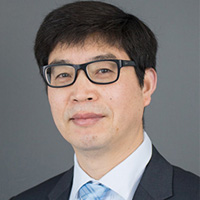 Dr. Conghe Song, Professor of Geography, University of North Carolina, Chapel Hill
Friday, September 4, 2020
3:30 pm to 4:30 pm
Since late 1990s China adopted a series of forest restoration and conservation programs after serious natural disasters resulting from long-term environmental degradation caused by unsustainable use of natural resources. In this talk, I will present the socioeconomic effects of the Conversion of Cropland to Forest Program (CCFP) and Ecological Welfare Forest Program (EWFP) on rural land use, out migration and household fuel choice and consumption in a remote mountainous township, Tiantangzhai, Anhui Province. CCFP is a forest restoration program that encourages farmers to convert croplands on slopes to forests for soil and water conservation based on the scheme of payment for ecosystem services. EWFP pays farmers to conserve forests that are of vital ecological value to the public. After controlling for other socioeconomic and environmental factors, we found CCFP strongly facilitated out migration and temporarily reduce cropland abandonment, while EWFP demotivated out migration and encouraged stable cropland usage. Neither program had a strong influence on rural household energy choice and fuel wood use. These findings highlight the need to coordinate concurrent conservation programs for achieving the targeted socioeconomic and ecological goals.
Conghe Song is currently a Professor of Geography and fellow in the Carolina Population Center at the University of North Carolina at Chapel Hill. He obtained his PhD degree from Boston University in Geography in 2001 and joined the Department of Geography at UNC Chapel Hill in the same year as an assistant professor, and subsequently rose through the ranks. He served as the Associate Chair and the Director for the Graduate Certificate Program in Geographic Information Sciences in the Department of Geography at UNC Chapel Hill during 2013-2019.
Dr. Song’s research focuses on three thematic questions: (1) how the land surfaces are changing through time? (2) what are the socioeconomic and ecological consequences of these changes? and (3) what are the forces that drive these changes? He uses remotely sensed data to measure land surface changes through time, such as biophysical parameters, land cover/land-use, and land surface phenology. He employs ecological models to integrate remote sensing and ground observation to understand how terrestrial ecosystem functions change as a result of land-cover/land-use change and climate change. He integrates household surveys, remote sensing and GIS, statistical models and agent-based models to understand the dynamics of coupled natural and human systems. He served as the PI for multiple grants funded by NSF, NASA and US Forest Service. His publications appeared on Remote Sensing of Environment, Global Change Biology, Nature, Ecology, Ecological Economics, Forest Policy and Economics, Population and Environment, and Land Use Policy et cetera. According to Google Scholar, his works had been cited for more than 7,000 times.
Continental-Scale Hydraulic Gradients
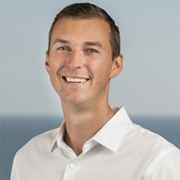 Dr. Scott Jesechko, Assistant Professor of Water Resources, Bren School of Environmental
Science and Management, University of California, Santa Barbara
Dr. Scott Jesechko, Assistant Professor of Water Resources, Bren School of Environmental
Science and Management, University of California, Santa Barbara
Friday, September 25, 2020
3:30 pm to 4:30 pm
Scott Jasechko is an Assistant Professor of water resources with the Bren School of Environmental Science & Management at UCSB. He completed his masters at the University of Waterloo, his doctorate at The University of New Mexico, three years as faculty at the University of Calgary, before joining UCSB in November 2017. Scott’s research uses large datasets to understand how we can preserve the quality and sustain the quantity of river water and groundwater resources around the globe. Scott’s work has been recognized by numerous early career awards, including the Horton Hydrology Research Award from the American Geophysical Union (2013), the Young Scientist Award from the Canadian Geophysical Union (2016), and the Kohout Early Career Award from the Geological Society of America (2018).
How Should We Scale From Trees to Landscapes? Predictions and Uncertainties for Forest Ecology in a Changing Climate
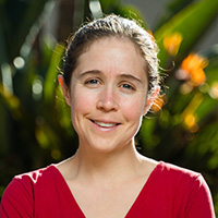 Dr. Anna Trugman, Assistant Professor of Geography, University of California, Santa
Barbara
Dr. Anna Trugman, Assistant Professor of Geography, University of California, Santa
Barbara
Friday, October 2, 2020
3:30 pm to 4:30 pm
Climate change has the potential to massively disrupt terrestrial ecosystem productivity, impacting biodiversity and ecosystem services, and driving Earth’s forests to release carbon into the atmosphere, which would further exacerbate climate change. Critically, the physiological mechanisms underpinning forest responses to climate are not fully understood due to complex interactions between climate, tree physiology, and community ecology. Here, I will talk about research leveraging an extensive trait database and a long-term continental forest plot network to map changes in community trait distributions and quantify ‘trait velocities’ (the rate of change in community-weighted traits) for different regions and different forest types across the U.S. from 2000 to the present. Next, I will highlight strengths and limitations in current traits-based approaches used to scale individual-based responses to processes, with a particular focus on drought driven tree mortality.
Anna Trugman received her bachelors degree from Stanford University in Geological and Environmental Sciences and her Ph.D. from Princeton University in Atmospheric and Oceanic Sciences. She has been an Assistant Professor in the Department of Geography at UC Santa Barbara since 2019.
Tobler‘s Law, Hurst’s Exponent, and Upper Ocean Turbulence
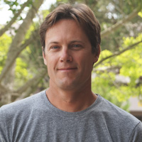 Dr. Nick Nidzieko, Assistant Professor of Geography, University of California, Santa
Barbara
Dr. Nick Nidzieko, Assistant Professor of Geography, University of California, Santa
Barbara
Friday, October 9, 2020
3:30 pm to 4:30 pm
A precise definition of “size”--encompassing both horizontal and vertical lengths scales--is essential to interpreting patterns in open ocean productivity. Whereas the physical boundaries of many ecosystem are quasi-stationary and often readily delineated by landforms, the boundaries of oceanic provinces are both subjective and fluid in time. In this talk I will consider how allometric relationships developed to quantify watershed characteristics can also be used to describe features generated by upper ocean mixing currents.
Nick Nidzieko is an Assistant Professor in the Department of Geography at UCSB. His work focuses on the contribution of physical processes in marine ecosystems and biogeochemical cycling.
Transit and Service Routing: Are We Really Finding Optimal Solutions, Does it Matter?
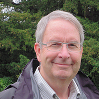 Dr. Richard Church, Distinguished Professor Emeritus of Geography, University of California,
Santa Barbara
Dr. Richard Church, Distinguished Professor Emeritus of Geography, University of California,
Santa Barbara
Friday, October 16, 2020
3:30 pm to 4:30 pm
The Arthur Getis Distinguished Lecture
This presentation discusses the three formulations, regarding transit and service routing, by Current et al. (1984; 1985) and Curtin and Biba (2011) and analyzes these three models when applied to a simple network. We demonstrate that these formulations may prevent optimal solutions or even feasible solutions from being found, even when they appear to be general and completely encompassing. Part of this can be explained as the result of a patently false premise under which these models were formulated and another part can be explained as the result of embedded errors in their formulations. New formulations will be developed which overcome these deficiencies and computational results will be presented.
Richard Church is Distinguished Professor Emeritus at the University of California, Santa Barbara. He received his PhD in Engineering from Johns Hopkins University. He is an expert in Operations Research and Management Science. Before coming to UCSB he was an associate Professor of Civil Engineering at the University of Tennessee. He has formally taught courses in Geography, Industrial Engineering, Management Science, and Civil Engineering. He has published two books on Location Science and more than 250 papers in Regional Science, Geography, Transportation, Operations Research, Environmental Modeling, and Engineering.
Jump In, the Water‘s Fine: Participatory Approaches to Freshwater and Coastal Resource Management
 Dr. Barbara Quimby, Research Scholar, Kyl Center for Water Policy, Arizona State University
Friday, October 23, 2020
3:30 pm to 4:30 pm
Engaging resource users and local communities in environmental planning and management is increasingly common, but the forms of this process vary and their outcomes are inconsistent. This talk presents research on stakeholder participation in local management decision-making and community-led research from two projects: a marine comanagement program in Samoa and a USDA-funded effort in Arizona addressing water and agriculture. In each context, participation in sustainable management planning is shaped by existing institutions, cultural values, and local perceptions of fairness.
Monitoring the COVID-19 Outbreaks in San Diego with Social Media, GIS, and Big Data
 Dr. Ming-Hsiang Tsou, Professor of Geography, San Diego State University
Friday, November 6, 2020
3:30 pm to 4:30 pm
Social media, GIS and Big Data can have important applications in public health, disaster management, transportation, and urban planning. The HDMA Center at SDSU are working with data scientists to monitor and track COVID-19 outbreaks in San Diego using Geographic Information Systems (GIS), machine learning algorithms and natural language processing and to study human communications and movements during this outbreak (https://hdma-sdsu.github.io/). This talk will provide an overview of the current research efforts dedicated to track and monitor COVID-19 in San Diego. However, these technologies also monitor users’ digital footprints, opinions and geolocations and they can be used for the invasion of privacy. The talk will also address the privacy concerns and how to balance between scientific research works and privacy protection.
Dr. Ming-Hsiang (Ming) Tsou is a Professor of Geography and the Founding Director of the Center for Human Dynamics in the Mobile Age at SDSU. His research interests are in Big Data, Human Dynamics, Social Media, Cancer Disparity, Web GIS, and Cartography. Dr. Tsou has published 92 refereed articles and received over $4 million federal funding (as PI or Co-PI) in the last ten years from NSF, NASA, and NIH.
Bridging the Gap: Integrating Critical Human and Physical Geography in Practice
 Dr. Rebecca Lave, Professor of Geography, University of Indiana, Bloomington
Friday, November 13, 2020
3:30 pm to 4:30 pm
The relationship (or lack thereof) between physical and human geography is a longstanding discussion within our field. Some commentators assume the possibility of synthesis and call for integrated work; others assume that deep integration is neither possible nor desirable. But even a brief review of the literature makes two points glaringly clear: this discussion has been going on for a long, long time and, given its regular reoccurrence, it would seem we have little to show for it. Rather than debate the possibility or desirability of such integration, I argue here that there is already a strong and growing body of work that draws together critical human and physical geography in an emerging sub-field: critical physical geography. Individually or in teams, critical physical geographers are bridging the gap, combining insights from geomorphology, ecology, and biogeography with approaches from political ecology, science and technology studies, and environmental history. The key characteristics that unify this work are its emphasis on treating physical processes and unequal power relations with equal seriousness, its acknowledgment of the politics of knowledge production, and its normative agenda of using research to promote eco-social transformation. By way of illustration, I present the results of a critical physical geography study of market-based environmental management in the US that I conducted with Martin Doyle (Duke), and Morgan Robertson (U Wisconsin). Drawing on social science data from document analysis and interviews and natural science data from geomorphic fieldwork, I argue that while the fluvial landscape bears a clear signature of environmental policy, the development of ecosystem service markets in “stream credits” has different consequences than could be expected.
Rebecca Lave is Professor and Chair of the Department of Geography at Indiana University. Her research takes a critical physical geography approach, combining political economy, STS, and fluvial geomorphology. She has published in journals ranging from Science to Social Studies of Science, and is the author of Fields and Streams: Stream Restoration, Neoliberalism, and the Future of Environmental Science (2012), the lead editor of the Handbook of Critical Physical Geography (2018), and the co-author (with Martin Doyle) of Streams of Revenue: The Restoration Landscape and Ecosystems it Creates (2021). Her current research focuses on the eco-social history of the U.S. Midwest.
Climatology of Sundowner Winds in Santa Barbara, California
 Dr. Charles Jones, Professor of Geography, University of California, Santa Barbara
Friday, December 4, 2020
3:30 pm to 4:30 pm
Dr. Charles Jones is a Professor in the Department of Geography and Researcher at the Earth Research Institute, UCSB. I have a B.S. in Meteorology from the University of São Paulo, Brazil, M.Sc. in Meteorology from the University of Utah and Ph.D. in Atmospheric Sciences from the University of California Davis. I have a broad research interests in Dynamic Meteorology and Climate Sciences. Research topics include: the Madden-Julian Oscillation (MJO), predictability of extreme events including precipitation, monsoon systems, climate change, regional modeling and wildfires. His current research projects include the dynamics of the low-level jet and precipitation variability in South America, regional modeling of Sundowner winds and wildfires in Santa Barbara, fog variability in the Santa Barbara Channel Islands and climate change in southern California.
Understanding Food Access: Going Beyond Traditional Measures
 Dr. Madison Swayne, Assistant Professor of Public Affairs, San Diego State University
Friday, January 29, 2021
3:30 pm to 4:30 pm
New advances in online routing applications and mobile phone GPS services have opened up new opportunities to understand accessibility to important destinations, as well as patterns of access. In my work, I use these data and techniques to understand access to grocery stores for transit-dependent populations using public transit travel times and to understand changes in the demand for food banks inlight of the COVID-19 pandemic.
Madison Swayne is an Assistant Professor of City Planning in the School of Public Affairs at San Diego State University. She is a social science researcher who uses mixed-methods including big data, automated computing methods, and primary data sources to answer research questions at the intersection of environmental justice and land use. Her research examines how urban form, real estate development, environmental policies, and nuisance continue to reproduce and exacerbate well-documented patterns of environmental injustice. Swayne teaches courses in environmental planning, land use and environmental law, and sustainable urbanism. Before joining SDSU, Swayne completed her Ph.D. in Urban Planning and Development at the University of Southern California. She has a Master’s and Bachelors’ of Science in Environmental Studies from the University of Southern California and has worked in environmental consulting in Southern California.
From Mario Kart to Pro-Poor Environmental Governance
 Dr. Andrew Bell, Assistant Professor of Earth and Environment, Boston University
Friday, February 5, 2021
3:30 pm to 4:30 pm
Improving environmental stewardship requires improvement of the options available down to the poorest resource users. Agriculture will no longer be the path to development and better options that it once was, without rethinking how and where to intervene. I use an iconic video game as a lens into how some of this can happen, and discuss how I plan to apply it - that is, to “Mariokartize” environmental development - in current work to evaluate payments for ecosystems services (PES) in the Shire River Basin in Malawi.
My research focuses on the use of surveys, behavioral experiments, and agent-based models to understand decision-making in the areas of: agricultural development, water management, migration, and livelihoods.
Mountain Goat Conservation and Restoration in Washington
 Dr. David Wallin, Professor of Environmental Sciences, Western Washington University
Friday, February 19, 2021
3:30 pm to 4:30 pm
Mountain goat populations in the Cascades Range of Washington State have declined from about 10,000 in the late 1950s-60s to about 3,000 today. Most of this decline is thought to be the result of overhunting from the 1960’s through the late 1980’s. I will discuss collaborative research and restoration efforts that have been underway over the past 15 years.
My research focuses on the regional-scale study of land-use effects on the structure and function of forest ecosystems. My work is heavily dependent on the use of simulation models, GIS, and satellite remote sensing. Although most of my work takes place in the Pacific Northwest, I’ve also been involved in comparative studies of land-use effects on forest structure in other parts of the world. Much of my recent work has focused on wildlife conservation and restoration and on the emerging field of landscape genetics.
Bonanza en los Andes, Student-led Water Development in Aurite, Perú
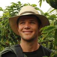 Dr. Jasper Oshun, Assistant Professor of Geology, Humboldt State University
Friday, March 5, 2021
3:30 pm to 4:30 pm
Bonanza en los Andes, was a two-year Geoscientists Without Borders (GWB) funded project focused on the Andean community of Zurite, Perú. Bonanza was designed around three interconnected themes: 1) a community based irrigation canal development project; 2) a hydrogeologic investigation of water resources in the understudied Andean puna; and 3) an educational program designed to train students in multidisciplinary research to bridge gaps between science and society.
View a video of Dr. Oshun’s project.
Dr. Oshun is a geologist whose research focuses on surface processes in the critical zone, ecohydrology, fluvial geomorphology and water resources. In particular, he centers his research on the effects of human activities on water resources in Northern California areas as well as international areas (Ecuador and Perú.)
Climate Change and Groundwater
 Dr. Hugo Loaiciga, Professor of Geography, University of California, Santa Barbara
Friday, March 26, 2021
3:30 pm to 4:30 pm
Hugo A. Loáiciga, Ph.D., P.E., D.WRE, Distinguished Member of the American Society of Civil Engineers (ASCE), is an eminent hydrologist. He was selected by ASCE to its 2018 class of Distinguished Members for his groundbreaking and standout contributions to the understanding of the effects of climate processes on the recharge and the safe yield of aquifers, and for the improvement of groundwater management. He is a Fellow of the American Association for the Advancement of Science (AAAS). Among other awards he has received, attesting to the importance of his contributions, are the Walter L. Huber Civil Engineering Research Prize, the Arid Lands Hydraulic Engineering Award, and the Julian Hinds Award. Dr. Loáiciga’s profound contributions have advanced environmental hydrology in the areas of watershed hydrology, hydrologic hazards, sustainable water resources management, regional hydrogeology, stochastic hydrology, and global-scale hydrologic processes. His early work on global warming and the hydrologic cycle, dating back to 1996, significantly enhanced today’s grasp of this topic long before there was an appreciation of its impacts. He has co-authored 356 scientific and technical articles, and teaches undergraduate and graduate courses in hydrology and water resources management in the Department of Geography at the University of California, Santa Barbara.
Hybrid Urban Borderlands – An Urban Landscape- and Border-Theoretical Approach to the Redevelopment Processes In and Around Downtown San Diego
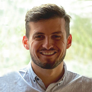 Albert Roßmeier, M.A.; PhD Candidate, Saarland University, Germany
Friday, April 9, 2021
3:30 pm to 4:30 pm
In recent years, downtown San Diego and its surrounding neighborhoods have experienced far-reaching urbanization and gentrification processes. In addition to the physical-structural developments which have reshaped the urban landscape, social upheavals have become apparent that still await in-depth analysis. In my talk, I will address individual interpretations and attributions in the context of San Diego’s downtown redevelopment from a phenomenological-oriented social constructivist urban landscape perspective. Within the aim of creating a wider understanding of the current upheavals, I am expanding my perspectival framework by exploring the potential of border-theoretical thinking for the research of individual experiences of neighborhood change, gentrification, and concomitant processes of social ‘b/ordering’ and ‘othering’. Surprisingly, border theories have only recently been applied on the level of urban neighborhoods, although these are particularly characterized by aspects of affiliation, differentiation, and participation. In response to this, I will illuminate the interdisciplinary benefits of this triangulation and illustrate how the ambiguous interpretations of San Diego’s changing central neighborhoods are creating fuzzy transition zones which I call hybrid urban borderlands.
Albert Roßmeier graduated in landscape architecture with a focus on urban planning at the University of Applied Sciences Weihenstephan-Triesdorf, followed by human geography at the University of Tuebingen. In Weihenstephan, he was employed from winter 2015 to winter 2016 as a research assistant in a project on landscape change and perception in the wake of the energy revolution, funded by the Federal Agency for Nature Conservation. From winter 2016 to spring 2019, he conducted research at the University of Tuebingen in the EU project ‘LIFE living Natura 2000,’ among others. He is currently working on his dissertation project on the transformation of inner-ring neighborhoods and urban ‘b/ordering’ processes in San Diego. His research interest includes energy system transformation, landscape change and theories, discourse theory, and urban/regional development in Europe and North America.
Understanding Supraglacial Rivers on the Greenland Ice Sheet
 Dr. Vena Chu, Assistant Professor of Geography, University of California, Santa Barbara
Friday, April 16, 2021
3:30 pm to 4:30 pm
Supraglacial rivers on the Greenland ice sheet transport large volumes of surface meltwater to the ocean, yet they are not well understood. This presentation will 1) characterize supraglacial river hydraulics from field observations; 2) compare direct measurements of supraglacial river discharge with modeled runoff; and 3) map supraglacial rivers using high-resolution satellite imagery.
Vena W. Chu is an Assistant Professor in the Department of Geography at UCSB. She received the Ph.D. degree in Geography from UCLA, and was also a University of California President’s Postdoctoral Fellow at the UC Berkeley Department of Geography. Her research employs geospatial technologies and field observations to study Arctic hydrologic systems in a changing climate, particularly to understand Greenland Ice Sheet hydrology from snow to sea.
Resources for Health and Well-Being across Latinx Destinations
 Dr. Liz Ackert, Assistant Professor of Geography, University of California, Santa
Barbara
Dr. Liz Ackert, Assistant Professor of Geography, University of California, Santa
Barbara
Friday, April 23, 2021
3:30 pm to 4:30 pm
The COVID19 pandemic has exposed place-based health vulnerabilities among Latinos/as. Geographic variation in health services and barriers to accessing these services have key implications for Latinx health access and outcomes in the COVID19 era and beyond. This research examines differences in general health services, immigrant-relevant health services, and barriers to accessing health services across Latinx communities. We investigate how health services and barriers to access differ across U.S. counties according to their histories as Latinx-receiving gateways.
I am an Assistant Professor in the Department of Geography at the University of California, Santa Barbara. My research interests include racial/ethnic inequality, immigration, education, health disparities, urban geography, and quantitative methods.
Ecosystem Services Assessment and Mapping with Pacific Northwest Stakeholders
 Dr. Stephen Crook, Assistant Professor of Geography, Palomar College
Friday, April 30, 2021
3:30 pm to 4:30 pm
Over the last 25 years, the ecosystem services concept - the idea that humankind receives a variety of benefits from ecosystems - has been embraced globally by agencies tasked with conserving natural resources. However, there is a lack of clarity related to how the concept can be applied to decision-making processes and there are few examples of the concept being used to change management outcomes. My research has focused on engaging stakeholders in the identification and mapping of ecosystem services in a way that can more effectively and equitably inform the movement toward ecosystem service-based management in the US National Forest context. Such participatory methods can provide rich and meaningful answers to the fundamental questions of “which” ecosystem services should be considered and “where” those are most valued within a management unit. By engaging public lands stakeholders as a first step in ecosystem services-based management, agencies can fulfill statutory requirements to include ecosystem services in planning while better understanding human values related to public lands.
Stephen Crook is a 2020 graduate of the Joint Doctoral Program in Geography at SDSU and UC Santa Barbara, where he specialized in human-environment interaction, environmental policy, and conservation GIS. Broadly, his research has focused on using (and often integrating) social surveys, participatory mapping, and remote sensing data to understand perceptions of, use of, and impact on natural areas. He is an Assistant Professor of Geography and GIS at Palomar College where he spends his time writing GIS labs and planning geography field courses for a post-pandemic world!
Dissertation Presentations
Squatting Historic Urban Landscapes: Analyzing Discourse and Experiences of Informal
Housing in Bucharest
Jasmine Arpagian
Thursday, July 22, 2021
9:00 am to 10:00 am
Thesis Presentations
Monitoring Cropping Systems in California’s Imperial Valley Using a Tri-space Approach
Kyle Jones
Friday, August 14, 2020
2:00 pm to 3:00 pm
Conifer Seedling Survivorship Following Post-Fire Reforestation at Cuyamaca Rancho
State Parkspan
Jeanne Patton
Wednesday, September 9, 2020
2:00 pm to 3:00 pm
Forests Mitigate Drought in An Agricultural Region of the Brazilian Amazon: Atmospheric
Moisture Tracking to Identify Critical Source Areas
Ye Mu
Wednesday, March 10, 2021
1:30 pm to 2:30 pm
A Signature-based Approach to Quantify Soil Moisture Dynamics under Contrasting Land-uses
Ryoko Araki
Thursday, April 29, 2021
11:00 am to 12:00 pm
An Analysis of Eucalyptus: The Culturally Invasive Species of San Diego
Cole Agenbroad
Thursday, May 6, 2021
2:00 pm to 3:00 pm
Geovisualization and Descriptive Analysis of Landscape Level Wildfire Behavior using
Repeat Pass Airborne Thermal Infrared Imagery
Keaton Shennan
Friday, May 7, 2021
9:30 am to 10:30 pm
The Effects of Land Use and Direct Channel Interventions on Stream Channel Evolution
in Los Laureles Canyon Watershed, Tijuana, Mexico
Benjamin Downing
Tuesday, May 11, 2021
12:00 pm to 1:00 pm
Mapping Environmentally Sustainable Urban Development within Six US Cities through
Object-Based Image Change Analysis of Aerial Orthoimagery
Noah Young
Tuesday, May 18, 2021
2:30 pm to 3:30 pm
General Events
Climate Talks
 Presented by the Geography Graduate Student Association
Monday-Wednesday, April 12-14
4:00pm-6:00pm daily
The Geography Graduate Student Association (GGSA) is proud to announce the first annual Climate Talks event intended to catalyze engagement with the climate and climate science communities, and provide a platform for thoughtful and interdisciplinary conversations about an extremely important topic. Hear from professionals and community members about their experience and perspectives on a variety of climate-related topics, including Physical Mechanisms, Impacts, Histories, Ethics, Policy, Law, etc. and how these contribute to the development of understanding climate and climate science.
The Panel Talks will be held over three days, Monday-Wednesday, April 12-14, between 4:00pm and 6:00pm. These will be virtual webinars held via Zoom. Registration is required.
Panel topics:
- Monday, April 12: Climate: What Should We Know About It?
- Tuesday, April 13: Climate Science from Different Perspectives
- Wednesday, April 14: Climate Law and Policy
To find out more information and to register for the event, please visit the GGSA website
American Society for Photogrammetry and Remote Sensing Pacific Southwest Region Spring Technical Meeting
Presented by the SDSU Student Chapter of ASPRS
Friday, April 16, 2021
2:00pm-4:30pm
Please join the American Society for Photogrammetry and Remote Sensing (ASPRS) Pacific Southwest (PSW) Region and San Diego State University (SDSU) Student Chapter of ASPRS on Friday, April 16th, 2021 for our Spring Technical Meeting. It will be held over Zoom from 2:00-4:30 pm PDT.
2:00-2:30: Dr. Cindy Schmidt (BAERI/NASA) will speak about satellite observations for nature and people, and will share the work she has done with Indigenous communities. Dr. Schmidt has over 25 years of experience in remote sensing and GIS technology for natural resource management, urban planning, and human health risk assessment.
2:30-3:00: Dr. Kenneth Field (Esri Inc) is a cartographer, data visualization wizard, and self described “cartonerd” who regularly blogs his cartographic creations and shows users what is possible with Esri software.
3:00-3:30: Dr. Karen Joyce (James Cook University in Cairns, Australia; She Maps; GeoNadir) will discuss her work with drones and imaging the Great Barrier Reef in Australia. In addition to teaching, she is the co-founder and Education director of She Maps and GeoNadir, both of which focus on geospatial technology and drone imaging.
3:30-4:30: Plenary Talk. Dr. Vena Chu (UC Santa Barbara Geography) will speak about supraglacial rivers on the Greenland Ice Sheet. Her research uses geospatial technologies and field observations to study Arctic hydrologic systems in a changing climate.
Meeting attendance and registration through ASPRS are free. To learn more about the event and the registration instructions, refer to the attachment.
There will be time following the presentations for additional Q&A from 4:30-5:30 pm PDT. This will be a great event to learn about current remote sensing, photogrammetry, and GIS research projects and opportunities. We hope you can join us!
Colloquia Series
Resilience to Earthquakes and Droughts: Some Insights from the Israeli Experience
Dr. Eran Feitelson
Head, Advanced School for Environmental Studies
The Hebrew University of Jerusalem, Israel
Friday, September 20, 2019
3:30 pm to 4:30 pm
Storm Hall 316
California and Israel are prone to both droughts and earthquakes. Yet the two types of disasters have very different attributes. While earthquakes are sudden, deadly and threaten mainly urban centers, droughts are slowly evolving, often multi-year, affect mainly farming and natural ecosystems with very little effects on the urban fabric. In this talk, I discuss the extent to which Israel is resilient to these two diametrically opposed types of disasters.
Through the implementation of a wide set of policy tools, most recently large-scale seawater desalination, Israel has largely decoupled itself from the effects of droughts (with the exception of the Jordan River basin). Israel has also invested much effort in immediate responses to earthquakes. However, little has been done in Israel with regard to the retrofitting of older buildings – the buildings most likely to be affected by earthquakes. Thus, the most effective measure to reduce casualties has lagged behind, as well as the preparation for the day after. Thus, the overall picture is that the highest risks are not addressed, while lesser risks are better addressed.
I explain these results from two perspectives – the first is the frequency of events and the second is the institutional structures in place. These explanations are hypothesized to be pertinent also in other settings.
Eran Feitelson is a professor at the Department of Geography of the Hebrew University of Jerusalem. He is the founder and first head of the Advanced School for Environmental Studies, a previous head of the Federmann School of Public Policy and Government and previous chair of the Department of Geography. He has published extensively in the fields of water policy, trans-boundary water, transport policy, land use planning, environmental policies and more recently earthquake preparedness. In addition to his academic work Eran Feitelson has participated in several national planning teams and has been a member of various national committees. He also serves for the second time as chair of the Israeli National Parks and Nature Reserves Commission.
Tracking Infectious Diseases Using Big Data: A Primer Using Search Data and Social Media
Dr. Eyal Oren
Associate Professor, Epidemiology & Biostatistics
Graduate School of Public Health
San Diego State University
Friday, September 27, 2019
3:30 pm to 4:30 pm
Storm Hall 316
This presentation focuses on the utility of big data sources to provide unique real time information on common and not-so-common infectious diseases. We will examine how the age of ‘digital epidemiology’ allows us to track disease spread and provides information pertinent to assessing clinical parameters such as the severity of infections using search and social media. We will also assess how both information and ‘misinformation’ feeds into public perceptions and resulting actions in the face of an infectious disease outbreak.
Eyal Oren is Associate Professor of Epidemiology at San Diego State University, with training as an infectious disease, spatial and social epidemiologist. He has extensive experience in epidemiological and clinical research, working on the effective adoption of interventions in the community as well as in developing evidence-based strategies and practices from secondary data analyses and novel data sources. He is particularly interested in using crowd-sourced and participatory data to enhance population health research. He holds a PhD and MS in epidemiology from the University of Washington.
50 Years of Geography, at SDSU and Around the World
Dr. Philip Pryde
Professor Emeritus of Geography
San Diego State University
Friday, October 25, 2019
3:30 pm to 4:30 pm
Storm Hall 316
Dr. Pryde will talk informally about how both the Department at SDSU, and the discipline of Geography in general, have changed since he arrived on Campus in 1969. He will also look at attractive future scenarios for the discipline. Dr. Pryde always saves time for a robust question and answer period.
Dr. Philip Pryde is a Professor Emeritus at SDSU, where he taught courses in environmental policy for 32 years. His specialties were water resources, energy resources, land use planning, and environmental impact analysis.
California Environmental Flows Framework: Striking the Balance Between Ecological and Human Water Uses
Dr. Kristine Taniguchi-Quan
Hydrologist
Southern California Coastal Water Research Project
Friday, November 1, 2019
3:30 pm to 4:30 pm
Storm Hall 316
Establishing environmental flow targets is a priority for numerous programs in California. Although methods vary based on the ecological endpoint of management concern (e.g. fish, macroinvertebrates, habitat), stream type, and preferences of the implementing agency, each effort aims to determine flow conditions necessary to protect ecological integrity in light of competing water uses. Unfortunately, lack of coordination among programs and efforts leads to inefficiencies, difficulty in comparing approaches, inability to share outputs, and creates potential for competing recommendations.
A statewide technical workgroup has convened to develop a framework for organizing environmental flow analyses across California and provide consistent science-based recommendations for applying appropriate methods to inform setting and managing of environmental flows. The California Environmental Flows Framework (CEFF) is a step-wise approach that promotes consistency and coordination in establishing, maintaining, and monitoring in-stream flow requirements for California. The overall goal of this effort is to support various regulatory and management agencies in developing and implementing local, regional, and statewide in-stream flow targets to protect aquatic life beneficial uses. Southern California case studies will be highlighted to illustrate urban water use challenges, and optimizing flows for ecological and human uses.
Kris Taniguchi-Quan is a scientist at Southern California Coastal Water Research Project (SCCWRP).
Threat Mitigation and Real-Time Forensic Support for Law Enforcement and the Intelligence Community Though Retaining Data Privacy for the Public at Scale
Jan-Philipp Mohr
Founder and Chief Executive Officer
Darvis, Inc.
Friday, November 8, 2019
3:30 pm to 4:30 pm
Storm Hall 316
Jan Philipp, Founder & CEO at DARVIS Inc, San Francisco (Data Analytics Real-World Visual Intelligence System)
Mentor at Founders Space in San Francisco
Started his career at an Investment banking boutique in Berlin and founded Darvis 5 years ago with two friends from Germany. Since then raised 7 million dollars in Venture Capital and scaled the team from 3 to 30 people.
A Spatial Data Science Framework for Movement
Dr. Somayeh Dodge
Assistant Professor of Geography
University of California, Santa Barbara
Friday, November 15, 2019
3:30 pm to 4:30 pm
Storm Hall 316
Movement is the driving force behind the form and function of many ecological and human systems. Identification and analysis of patterns of movement that may relate to the behavior or interactions of individuals is a fundamental first step in understanding these systems. Ubiquitous collection of geo-enriched tracking data necessitates new approaches for the analysis and sense-making of large and multidimensional arrays of information about movement of individuals, goods, vehicles and other mobile agents in space and time. To take advantage of the evolution in our data, effective representations and analytical approaches are necessary to reveal and communicate important patterns in spatiotemporal data sets and inform us about the processes involved in social and ecological systems. This study presents a data science framework and attendant methods for analysis, modeling, and mapping movement as a multidimensional process that involves space, time, context, and scale.
Somayeh serves as Assistant Professor of Spatial Data Science in the Department of Geography at the University of California, Santa Barbara. She received her PhD in Geography with a specialization in Geographic Information Science (GIScience) from the University of Zurich, Switzerland in October 2011. She holds a MS degree in GIS Engineering and a BS degree in Geomatics Engineering from the KNT University of Technology, Iran. Somayeh’s research focuses on developing data analytics, knowledge discovery, modeling, and visualization techniques to study movement. Her research applies spatial data science and computational approaches to advance the knowledge and understanding of how movement patterns are formed in dynamic natural and human systems. She has published in a number of high-ranked international journals such as Methods in Ecology and Evolution, International Journal of Geographic Information Science, Philosophical Transactions of the Royal Society B, Journal of Spatial Information Science, Movement Ecology, Computers, Environment and Urban Systems (CEUS), Geographical Analysis, and Information Visualization. Somayeh currently serves as the Editor in Chief of the Journal of Spatial Information Science. She is involved in the editorial boards of multiple journals including Geographical Analysis, CEUS, and The Professional Geographer.
Metabolism of Cities: Localizing the United Nations Sustainable Development Goals by 2030
Dr. Gabriela Fernandez
Adjunct Professor
San Diego State University
Friday, December 6, 2019
3:30 pm to 4:30 pm
Storm Hall 316
Metabolism of Cities (MOC) (registered in Brussels, Belgium) is an open source, community management, and engagement platform with the aim to group together tools, publications, and data related to urban metabolism studies. To examine patterns and trends in urban resource use, waste generation, and pollution across the globe. Urban metabolism studies vary widely in terms of scope, methodology, choice of indicators, and research aims to identify urban metabolic patterns across different cities. The presentation will provide an overview of the work developed by the Metabolism of Cities using urban metabolism methodologies, resource management education, and social campaigns to help cities localize the United Nations Sustainable Development Goals by 2030. The goal is to facilitate an articulated set of tools to support local stakeholders and their networks, under the leadership of local, regional, and national governments. By pointing out the best practices that are reliable and replicable in order to efficiently design, implement, and monitor policies through data management and engagement.
Gabriela Fernandez completed her Ph.D. in Urban Planning, Design, and Policy in the Department of Architecture and Urban Studies at Politecnico di Milano in Milan, Italy. In 2015, she was a Ph.D. Visiting Student at the Massachusetts Institute of Technology in the Department of Architecture, Building Technology, Urban Metabolism Group. Fernandez’s research focuses on urban metabolism ideologies and material flow analysis of metropolitan cities. Identifying urban typologies and socioeconomic indicators in the urban context while promoting urban metabolism public policy. Fernandez is Co-founder and Researcher at the Metabolism of Cities, a non-profit organization registered in Brussels, Belgium with data, tools, and publications related to urban metabolism studies. Fernandez received her Bachelor of Arts and Sciences in Public Administration with an emphasis in City Planning and a Master of City Planning from the School of Public Affairs at San Diego State University in San Diego, California, USA. Fernandez is an Adjunct Faculty in the Department of Geography at San Diego State University, in San Diego, CA.
The Kalunga Quilombola Community in Relation to Geographical Space
Dr. Maria Lidia Bueno Fernandes
Professor and Researcher of Education
University of Brasilia, Brazil
Friday, February 7, 2020
3:30 pm to 4:30 pm
Storm Hall 316
This presentation focuses on the traditional Brazilian community of Kalunga. It is one of the remaining Quilombo, which are Afro-Brazilian settlements initially established by escaped slaves. I will contextualize the locality from a historical-geographical point of view, in which I consider the physical environment, as well as political, social, economic, and cultural issues.
Maria Lidia Bueno Fernandes has a PhD in Geography from the University of São Paulo - USP. Magister Artium in Ethnology and Social Psychology by Ludwig-Maximilians-Universität in Munich, Germany. Graduated in Geography from the University of São Paulo - USP. Professor of the Faculty of Education and the Postgraduate Program in Education - PPG E of the University of Brasília - UnB, in the Line of Research: School, Learning, Educational Processes and Subjectivity. She completed post-doctoral training at the Universidade Federal Fluminense - UFF with the theme: Geography and childhood: culture and territory in dialogue with Cultural Historical Theory. She is the leader of the Research Group, Territories and the Construction of Knowledge - GPS / CNPq; member of the Research and Study Group on Childhood Geography; member of the Interdisciplinary Research Network on the protagonism and human rights of Latin American infants; member of the Rural Studies Network on Families, Infancy and Youth - RER-FIJ and the Latin American Network for Research and Reflection with Children and Youth - REIR.
Transgressions of Spatial Rigidity: How Black and Indigenous Women (Re)Story Movements
Dr. Esme G. Murdock
Assistant Professor of Philosophy
Associate Director, Institute for Ethics and Public Affairs
San Diego State University
Friday, February 21, 2020
3:30 pm to 4:30 pm
Storm Hall 316
Settler colonialism as a violent land-orientated, social-spatial system/structure is deeply committed to projects of spatial dominance that include conceptions of “nation” and “home” as fixed, bounded, and unchanging sites. In addition to this allegiance to spatial rigidity, settler colonialism also has dominant and oppressive attitudes toward both movement and migration, especially that of non-dominant, non-white Others. Critical geographers, especially those invested in complicating hegemonic constructions of space and place through exploring investigations of Black and Indigenous geographies, give us insight into how dominant spatial constructions cannot only be disrupted, but also (re)storied for the purposes of resistance. In this presentation, I will focus on the (re)storying of both migration and movement as a site of resistance, futurity, and self-determination as presented in the centering of Black and Indigenous women’s lived knowledges in North America. Specifically, I will examine how the migration and movement, as well as the obstacles to such migration and movement, of Black and Indigenous women reveals ruptures ripe for theorizing the indeterminacy and incompleteness of settler colonial projects of spatial closure.
Esme G. Murdock is Assistant Professor of Philosophy and Associate Director of the Institute for Ethics and Public Affairs at San Diego State University. She works in the areas of environmental philosophy and environmental ethics and social and political philosophy with particular attention to environmental justice, philosophies of race and gender, and settler colonial theory. Her research explores the intersections of social/political relations and environmental health, integrity, and agency. Specifically, her work troubles the purported stability of dominant, largely euro-descendent, and settler-colonial philosophies through centering conceptions of land and relating to land found within African American, Afro-Diasporic, and Indigenous eco-philosophies.
Documentary Film Screening: CITY RISING: The Informal Economy
Dr. Pascale Joassart-Marcelli
Professor of Geography
Documentary Co-Producer
San Diego State University
CITY RISING: The Informal Economy examines a growing segment of our economy, which consists of unregulated and unprotected jobs. It exposes this trend as the result of policy choices and practices that have historically kept many jobs out of reach for women, immigrants and people of color who have turned to the informal economy to make a living and support their communities. The film follows workers in California who labor off the books—often in plainsight—and are organizing to find pathways to legalization and protection.
Screening followed by Q&A with film co-producer Pascale Joassart-Marcelli.
The CITY RISING Series, produced by KCET in collaboration with the California Endowment, is a multi-platform initiative that highlights how individuals facing social and environmental injustice fight to change policy and lift up their communities.
Friday, March 6, 2020
3:30 pm to 5:30 pm
Arts & Lettters 101
Dissertation Presentations
The Relative Timing of Human Migration and Land Cover and Land Use Change — An Evaluation
of Northern Taiwan from 1990 to 2015
Hsiao-Chien (Ace) Shih
Monday, May 4, 2020
10:00 am to 11:30 am
Power and Participation in the Gataifale: A Comparative Analysis of Samoan Coastal
Marine Management
Barbara Quimby
Friday, December 6, 2019
10:00 am to 12:00 pm
Storm Hall 325
Assessing Patterns and Drivers of Structural and Compositional Change in Chaparral
of Southern California Using Time Sequential Satellite Imagery
Emanuel Storey
Thursday, August 8, 2019
2:00 pm to 4:00 pm
Storm Hall 325
Thesis Presentations
Evaluation of Thermal Infrared Imaging from Unmanned Aerial Vehicles for Arboreal
Wildlife Surveillance
Blair Mirka
Friday, June 26, 2020
11:00 am to 12:00 pm
A Longitudinal Study Evaluating the Effects of Payments for Ecosystem Services on
Species Richness
Alexandra Yost
Thursday, June 18, 2020
4:30 pm to 5:30 pm
Placed-Based Environmental Education and Environmental Justice in Imperial Beach,
California
Empress Holiday
Wednesday, June 17, 2020
1:00 pm to 2:00 pm
Hydrologic Change Along the All-American Canal in California’s Imperial Valley
Sarah Roberts
Monday, June 8, 2020
3:00 pm to 4:00 pm
Multi-temporal Fractional Cover Estimation of Shrubs on San Clemente Island
Kelsey Warkentin
Wednesday, May 27, 2020
2:00 pm to 3:00 pm
The Effects of Wildfires on Tropical South America’s Surface Climate
Zackary Werner
Friday, May 1, 2020
1:00 pm to 2:00 pm
Exploring Human Perceptions and Conflict Surrounding Human-Seal Use of Beaches in
California and Hawai’i
Leilani Konrad
Tuesday, February 4, 2020
11:00 am to 12:30 pm
Storm Hall 325
Evaluating Landscape-Level Controls of Wildfire Spread Rates Using Repetitive Airborne
Thermal Infrared (ATIR) Imagery
Gavin Schag
Friday, January 24, 2020
2:00 pm to 3:30 pm
Storm Hall 325
Histogram Curve Matching Approach for Geographic Object-Based Image Change Analysis
of Urban Land Use
Chi-Feng (Jeff) Yen
Friday, December 13, 2019
10:00 am to 12:00 pm
Storm Hall 325
Geochemical Sediment Source Identification in a Semi-Arid Urbanized Watershed: Implications
for Improved Soil Loss Modeling
Garrett McGurk
Friday, December 6, 2019
1:00 pm to 3:30 pm
Storm Hall 325
Indigenous Social Movement in Nayarit
Sam Orndorff
Wednesday, December 4, 2019
3:00 pm to 5:00 pm
Storm Hall 325
Coastal Erosion Risk Mapping of the San Diego Region: An Assessment of Spatial and
Temporal Change
Kristen Monteverde
Monday, August 19, 2019
11:00 am to 1:00 pm
Storm Hall 331
Urban Agriculture in San Diego: Garden Characteristics, Practices, and Environmental
Outcomes
Alyson Scurlock
Friday, August 2, 2019
10:00 am to 12:00 pm
Storm Hall 325
General Events
SDSU Student Chapter of ASPRS Workshops
Wednesday, March 4, 2020
8:30 am to 1:00 pm
All are invited to participate in a series of activities/workshops pertaining to drone imaging sponsored by the SDSU Student Chapter of the American Society for Photogrammetry & Remote Sensing (ASPRS). While you will get the most out of participation in all three activities, feel free to attend any of them.
- 8:30am - 10:30am: Drone Imaging Mission.
Actual research imaging mission involving drone-based thermal infrared imaging of simulated arboreal animal and real people targets.
Location: Bridge east of Villa Alvarado, between Parking 17 and 17C - 12:00pm - 1:00pm: Flight Planning for Drone Imaging.
Demonstration of drone flight planning tools
Location: Storm Hall 331
Additional workshop is scheduled for Wednesday, March 11, 2020.
Please R.S.V.P to Blair Mirka, ASPRS Chapter Vice President at [email protected]
if you plan to attend any or all of these activities.
SDSU Student Chapter of ASPRS Workshops
Wednesday, March 11, 2020
11:00 am to 12:00 pm
Please join the SDSU Student Chapter of the American Society for Photogrammetry & Remote Sensing (ASPRS) for a second day of workshops pertaining to drone imaging.
- 11:00am - 12:00pm: Drone Image Processing.
Demonstration of “Structure from Motion” software for generating digital surface models and orthoimage mosaics.
Location: Storm Hall 331
Please R.S.V.P to Blair Mirka, ASPRS Chapter Vice President at [email protected] if you plan to attend any or all of these activities.
Open GIScience
Wednesday, February 5, 2020
4:00 pm to 5:00 pm
Student Union, Templo Mayor
Dr. Sergio Rey
Professor of Public Policy
Director, Center for Geospatial Sciences
University of California, Riverside
San Diego State University
Distinguished Speaker Series
Sponsored by Department of Geography, College of Arts and Letters, Graduate and Research
Affairs
In this talk, I examine the field of Geographical Information Science (GIScience) from the perspective of broader developments surrounding open source software and the rising open science movement. Despite its reliance on code in general, and open source software in particular, GIScience has only recently begun to seriously engage with what are seismic shifts in the underpinnings of science driven by the open revolution. I suggest a number of possible explanations for this delayed engagement. Next, I discuss the obstacles to, and opportunities for, reinventing GIScience as an open science and transforming GIScience education. I highlight a selection of exemplar efforts leading the charge and offer some thoughts on likely future developments and possible ways forward for the discipline.
Sergio Rey is Professor in the School of Public Policy and Founding Director of the Center for Geospatial Sciences at UCR. Dr. Rey’s research interests focus on the development, implementation, and application of advanced methods of spatial and space-time data analysis. His substantive foci include regional inequality, convergence and growth dynamics as well as neighborhood change, segregation dynamics, spatial criminology and industrial networks. Recent and current research projects include geodemographic approaches to neighborhoods in space-time contexts (NSF), new methods for spatial distribution dynamics (NSF), an analysis of the relationships between spatial linkages and urban economic dynamics (EDA), flexible geospatial visual analytics and simulation technologies to enhance criminal justice decision support systems (NIJ), spatial analytical framework for examining community sex offender residency issues over space and time (NSF), and cyberGIS software integration for sustained geospatial innovation (NSF). Dr. Rey is the creator and lead developer of the open source package STARS: Space-Time Analysis of Regional Systems as well as co-founder and lead developer of PySAL: A Python Library for Spatial Analysis. He is an elected fellow of the Regional Science Association International, a fellow of the Spatial Econometrics Association, and has served as the Editor of the International Regional Science Review from 1999-2014, editor of Geographical Analysis 2014-2017, and the president of the Western Regional Science Association.
Geospatial Data for Forecasting Global Change Impacts on Ecosystems
Tuesday, February 4, 2020
4:00 pm to 5:00 pm
Student Union, Templo Mayor
Dr. Janet Franklin
Distinguished Professor of Botany and Plant Science
University of California, Riverside
San Diego State University
Distinguished Speaker Series
Sponsored by Department of Geography, College of Arts and Letters, Graduate and Research
Affairs
Human activities have altered global patterns of biodiversity, and key processes of energy balance and biogeochemical cycling in the Earth system, especially over the last 500 years. These changes have been so profound that they are detectable in the geological record and some have suggested that this is a new geological era, The Anthropocene. Owing to the anthropogenic global change agents—land use change, climate change, nitrogen deposition, altered disturbance regimes and transport of invasive species—the planet may have already moved outside of a safe operating space for humanity in several dimensions. I use geospatial data in my research for monitoring and forecasting the effects of land-use change (deforestation and urbanization leading to habitat loss and fragmentation), and climate change on biodiversity and ecosystem function. Processes leading to biodiversity loss are inherently spatial. Knowing where biodiversity is found is the basis for spatial conservation planning. Knowing where on the landscape threats occur in relation to biodiversity is prerequisite to monitoring impacts. Forecasting where threats might occur in the future allows prediction of future impacts. The effects of climate change on species and ecosystems is already detectable globally, with earlier arrival of spring affecting plant and animal phenology, bird and other animal migrations, and so forth, and with species distributions shifting in directions consistent with observed climate changes. I will show how static species distribution models, and dynamic population and community simulations, have been used to forecast the separate and combine impacts of climate and land use change on biodiversity and ecosystems.
Janet Franklin is a Distinguished Professor in the Department of Botany, University of California at Riverside where she has been since 2017. She was previously a Regent’s Professor in the School of Geographical Sciences and Urban Planning, as well as a Distinguished Sustainability Scientist at Arizona State University where she was appointed in 2009. From 1988-2009 she was and Assistant, Associate, and Full Professor on the faculties of Geography and Biology at San Diego State University. She received her Ph.D. in Geography from the University of California, Santa Barbara in 1988. She specializes in Landscape Ecology, Global Change Biology, Conservation Biogeography, and Geographic Information Science. Franklin’s research is focused on in the patterns and dynamics of terrestrial (land) plant communities at the landscape scale. Her work addresses the impacts of human-caused landscape change on the environment. Human land use—agriculture and urbanization—and other large-scale human impacts such as climate change, and the introduction of exotic species, often interact with natural disturbance regimes such as fire, flooding and hurricanes, to shape plant community dynamics in forests, shrublands, and other ecosystems. How resilient are ecological communities to these past, present and future impacts? She is a Member of the National Academy of Sciences, USA, and a Fellow of the American Association for the Advancement of Science, the American Academy of Arts and Sciences, and the Ecological Society of America. She is an Associate Member, Centre for Coastal Paleoscience, Nelson Mandela University, South Africa. She has published over 150 refereed journal articles and has received research grants from NSF, NASA, the USDA Forest Service, and USGS. Her book Mapping Species Distributions: Spatial Inference and Prediction (Cambridge University Press) has been cited over 2000 times.
Geography Awareness Week
Tuesday, November 12, 2019 to Friday, November 15, 2019
8:00 am to 4:00 pm
SDSU Campus
The Department will be hosting games and giving out swag, providing demonstrations of our UAV/drone capabilities, holding a career panel and an informational presentation on spatial data available in the library. Throughout the week, students, staff and faculty can contribute to the creation of the Best of SDSU Campus map using their phones. The week ends with a visit from high school students as the explore geography as a college major or career field.